Section C: Area Specific Policies
STRATEGY AREA 1: HEADS OF THE VALLEYS REGENERATION AREA (HOVRA)
SUB-REGIONAL CONTEXT
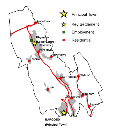
Bargoed is the principal town in the Caerphilly County Borough part of the Heads of the Valleys Regeneration Area (HOVRA). As the main town, Bargoed provides a range of functions and services for the surrounding settlements that are not available elsewhere in the Caerphilly part of the Heads of the Valleys area. The importance of the town is recognised by the Heads of the Valleys programme and as such the Welsh Assembly Government designates it as a regeneration priority area. It is anticipated that the development of the ‘Angel Way’ Relief Road will serve to improve the accessibility and attractiveness of the town and will act, as a catalyst to attract much needed public and private investment into Bargoed Town Centre.
The emphasis in Bargoed will be on restructuring and redeveloping the existing town centre to ensure that it is a viable retailing, leisure and employment centre and that it is fit for purpose in the 21st century. The Plan will also make sufficient provision to diversify the housing that is available within the area. The redevelopment of the town will improve the image of the whole of the HOVRA and will improve the range of important services and the leisure and retail offer available to the northern parts of the County Borough.
Bargoed and its suburbs are also part of the mid valleys conurbation and the town has an important role to play in the growth and well being of the County Borough as a whole. In particular, there may be an opportunity for Bargoed to develop as a centre for leisure activities for a large part of the County Borough if current interest by the private sector in developing a multiscreen cinema and other leisure facilities can be incorporated into the town centre redevelopment scheme.
A number of allocations policies will be implemented with the purpose of developing Bargoed’s role as the Heads of the Valleys’ Principal Town. CM4.2 allocates a major site for retail and entertainment facilities, to be integrated into the existing town centre. A new district library and a Council ‘customer-first’ centre are proposed in CF1.10. The town will also gain a role as a centre for office-based employment through the implementation of CM4.3 andCM5.1.
Rhymneyis the local centre for the HOVRA and it has the potential to provide a tourism gateway into the County Borough from the Heads of the Valleys area and further afield. Centrally located in terms of the HOVRA it is uniquely placed to help change the perception of the subregion through enhancing the visitor and tourism role the area has to offer, by for example the development of the Valleys Regional Park. A Health and Social Care Resource Centre is proposed for Rhymney to serve the north of the Borough. There are countryside recreation facilities in the area, which, together with the strategic cycle routes and footpaths that run throughout the area, contribute to the considerable potential for enjoyment of the rural environment that Rhymney has to offer
The area is also well served by the Rhymney to Cardiff Railway line, which now benefits from four trains an hour between Bargoed and Cardiff. However, for the rail network to offer an attractive alternative to the car for travel from the HOVRA to Cardiff, further improvements to provide a half hourly service to Rhymney are needed.
As indicated, Rhymney also comprises a significant amount of employment land on existing industrial estates. The changing pattern of employment land requirements indicates that these sites offer the opportunity to accommodate alternative uses, whilst retaining an employment function, potentially diversifying the role of Rhymney to the benefit of the whole area.
Rhymney’s identified role as a local centre will be facilitated through allocations under CF1.2, which will enable the development of the proposed Health and Social Care Resource Centre, and CM4.1, which will allow for new retail development on the edge of the town centre.
Road access to the Upper Rhymney Valley has been improved with the recent development of the new road at New Tredegar. When the Angel Way Relief Road is completed in 2009, road access from north to south will be improved in this area too
However, there is a continued need to improve the road network at key locations - in particular the substandard section of the A469 between New Tredegar and Pontlottyn - to bring the network up to a standard required to meet the needs of the 21st Century. PolicyTR8 seeks to address this, to ensure the HOVRA is to function effectively and in particular for the potential and benefits of Bargoed to be fully realised.
The Upper Rhymney Valley offers the most significant potential in terms of energy production within the county borough due to the presence of coal resources at Nant Llesg and the potential of the Upper Rhymney Valley area in terms of renewable energy generation.However, the area is also a principal gateway to the northern end of the County Borough and isparticularly prominent when viewed from the A465 Heads of the Valleys Road. The Plan seeks to balance the merits of renewable energy schemes and the safeguarding and potential development of minerals in this area against the objective of safeguarding the landscape fromfurther degradation and, where possible, securing landscape enhancement. Due to its prominence, any proposals for development associated with energy generation within the Upper Rhymney Valley will need to recognise that development must be undertaken in an environmentally acceptable manner. Development proposals should, where appropriate, secure effective landscape rehabilitation and enhancement as an integral part of the scheme. Proposals will also need to be consistent with the wider regeneration strategy and enhanced recreational and tourism role envisaged for this part of the Plan area.
Residential development will be concentrated on Bargoed and Rhymney, together with Pontlottyn, New Tredegar and Aberbargoed, which have good access to the rail network. Small-scale housing sites are allocated in the primarily residential villages of Princetown, Fochriw and Abertysswg, where there is a need for modern housing to maintain the viability of these former mining villages. 22 new housing allocations across the Heads of the Valleys’ smaller settlements are designed to introduce a range and choice of housing types and tenures in these locations and will strengthen their roles as residential centres. Policies CF1 and LE3 will allow the development of new community facilities in these settlements, enhancing their attractiveness as places to live.
The villages of Argoed, Hollybush and Markham in the Sirhowy Valley are primarily residential. Although they are located in the HOVRA, they have strong links with Blackwood, unlike the Upper Rhymney Valley settlements. In the Plan period, however, they are likely to develop links with Bargoed also, once the town centre has been redeveloped. No major change is envisaged in these rather isolated areas, though the surrounding countryside, which includes the Markham Colliery site, could make a significant contribution to the Valleys Regional Park.
It is recognised that the most northerly towns and villages in the County Borough will also look to Merthyr Tydfil and other towns along the Heads of the Valleys corridor for job opportunities and urban facilities. Good transport links to Merthyr Tydfil in particular are therefore important.
In terms of the Heads of the Vallerys generally, the functionality of both the identified centres and residential villages will be strenthened by improving the transport links between them. This will be achieved through the implementation of PoliciesTR1, TR4and TR8.
The area’s potential contribution to the Valleys Regional Park (an initiative set out within the Wales Spatial Plan) is immense and requires positive allocations, including country parks (Policy LE2) and cyclepaths (Policy TR1), as well as designations designed to protect the dramatic landscape that underpins the Park’s existence. Policies SI1, NH1andNH2 will serve to achieve this.
AREA SPECIFIC POLICIES FOR HOVRA
SETTLEMENT IDENTITY
The need to define and maintain open spaces between and within urban areas and settlements to prevent coalescence is considered important for the County Borough to protect the integrity of both the built and natural environment. Within green wedges, it is intended to resist any development proposal that would not maintain this open character.
The HOVRA has five green wedges. Development proposals will only be considered where the use is either conducive to the existing character or enhances the character of the green wedge. A detailed description of the green wedge allocations can be found in Appendix 3.
CONSERVATION OF NATURAL HERITAGE
Special Landscape Areas (SLAs) are local non-statutory designations that seek to protect areas that exhibit distinctive landscape, historical, cultural, biodiversity and geological features and characteristics within the County Borough. They are locally important elements of the natural heritage of the rural and urban environments, and provide a living history of the evolution of the area’s landscape as well as cultural backdrop and visual setting. The designation of SLAs highlights the holistic consideration of the landscape, with emphasis placed on the ‘special’ nature of the distinctive landscape features and characteristics in these areas.
Two special landscape areas have been identified in the HOVRA. These areas will be protected from any development that would harm their distinctive features or characteristics. The policy is not designed to preclude development. However, an applicant will need to demonstrate that any development proposal will not have an unacceptable impact on the specific distinctive features or characteristics associated with the SLA.
LANDMAP is the national information system for taking landscape into account in decision-making. It separates landscape into five aspect areas: geological landscapes, visual and sensory, landscape habitats, cultural landscapes and the historic landscapes. The system allows information to be gathered, organised and evaluated within a nationally consistent data set.All of the SLAs have been identified using LANDMAP information and SLA designation methodology. This recognises that an SLA may include small parts of the local landscape that do not display the same level of landscape importance. A detailed description of the SLA designations can be found in Appendix 1, which provides a breakdown of the distinctive landscape features and characteristics within each SLA.
Visually Important Local Landscapes (VILLs) are non-statutory designations that seek to protect the distinctive features or characteristics of the visual and sensory landscape of the County Borough and how we perceive and respond to the landscape around us. VILLS have been identified using only the visual and sensory layer of LANDMAP. The HOVRA has two Visually Important Local Landscapes.
Development will only be permitted where it conserves and, where appropriate, enhances the distinctive visual and sensory landscape features or characteristics of the VILL. Development proposals should demonstrate that these features of the visual and sensory LANDMAP aspect layer are conserved and, where appropriate enhanced for the benefit of the visual landscape. A detailed description of the VILL designations can be found in Appendix 2, which provides a summary of the distinctive visual and sensory landscape features and characteristics within the VILL.
NH3 – Sites of Importance for Nature Conservation (SINCs)
Sites of Importance for Nature Conservation are identified and will be protected at the following locations:
| NH3.1 | River Rhymney |
| NH3.2 | Pen March and Traed y Milwyr, Llechryd |
| NH3.3 | Bute Town, Llechryd and Rhymney Grasslands, Rhymney |
| NH3.4 | Nant Bargoed Rhymni, Darran Valley |
| NH3.5 | Tair Carreg Moor, North West of Fochriw |
| NH3.6 | Cwm-Llydrew Wood, South of Fochriw |
| NH3.7 | Nant Bargod Flush, Deri |
| NH3.8 | Cefn y Brithdir, South of Pontlottyn |
| NH3.9 | Mile End Pond, Abertysswg |
| NH3.10 | Y Graig Mire, South of Abertysswg |
| NH3.11 | River Sirhowy |
| NH3.12 | River Ebbw |
| NH3.13 | Cwmsyfiog Woodland, North of New Tredegar |
| NH3.14 | Coed Cefn-Rhychdir, North of New Tredegar |
| NH3.15 | Troed-Rhiw’r-Fuwch, North West of New Tredegar |
| NH3.16 | Parc Cwm Darran Larch Plantation, Deri |
| NH3.17 | Cefn Gelligaer, West of Deri |
| NH3.18 | Craig Ysgwydd-Gwyn, Deri |
| NH3.19 | Ysgwydd-Gwyn-Isaf Wood, South of Deri |
| NH3.20 | Coed Deri-Newydd, Deri |
| NH3.21 | Pont Caradog and Nant Llan Woodlands, East of Deri |
| NH3.22 | Tir-y-Ferch-Gryno, Brithdir |
| NH3.23 | Coed-y-Moeth and Cwmsyfiog Hillside, Cwmsyfiog |
| NH3.24 | Mynydd Manmoel, North of Manmoel |
| NH3.25 | Twyn y Bleiddiaid, South East of Manmoel |
| NH3.26 | Coed Waun-Bleiddian, North of Hollybush |
| NH3.27 | Hollybush Spring, Hollybush |
| NH3.28 | Llwyn-Bach Woodland, South of Hollybush |
| NH3.29 | Nant-y-Felin Wood, North East of Markham |
| NH3.30 | Markham Tips, North of Markham |
| NH3.31 | Pen-yr-Heol Meadows, Markham |
| NH3.32 | Markham Railway Line, Markham |
| NH3.33 | Pen- Rhiw’r-Eglwys, East of Markham |
| NH3.34 | Hafodrisclawdd, East of Markham |
| NH3.35 | Pen-y-Waun, South of Markham |
| NH3.36 | Markham Colliery, North of Markham |
| NH3.37 | Coed Argoed, East of Bedwellty |
| NH3.38 | Bedwellty Churchyard, Bedwellty |
| NH3.39 | Land opposite St Sannan’s Church, Bedwellty |
| NH3.40 | Nant Cwm-Crach, Bedwellty |
| NH3.41 | Nant-Gau and Darran Woodlands, North of Oakdale |
| NH3.42 | Caeau Cwm-Corrwg, North of Oakdale |
Sites of Importance for Nature Conservation (SINCs) are an important biodiversity resource covering significant areas of priority habitats and species. Designations are based on objective scientific criteria to accord with the (developing) Wales-wide guidelines. This policy applies to all sites that meet the criteria for designation.
Development will normally be permitted where it would not cause unacceptable harm to the particular features of the SINC. Where harm is unavoidable it should be minimised by effective mitigation measures to ensure that there is no reduction in the overall nature conservation value of the area or feature. Where this is not possible, compensation measures designed to conserve, enhance and manage locally distinctive natural habitats and species should be provided, including for example details of restoration and reclamation schemes. A description of thedesignated SINCs can be found in Appendix 4.
MINERALS AND WASTE HANDLING FACILITIES
The Cwmbargoed Disposal Point complex straddles the boundary of Caerphilly and Merthyr Tydfil County Boroughs. The majority of the site lying within Caerphilly County Borough is used for the preparation and despatch of coal. Other appropriate employment activities relying on the railhead facility and satisfying the sustainability principles of the Plan, for example waste management facilities and aggregates handling and despatch, would be acceptable. A detailed description of this site can be found in Appendix 6.
MINERALS
The development restrictions associated with this zone are described in Policy CW23 in section two of the Plan.
The Coal TAN (MTAN 2 - Coal)requires local planning authorities to safeguard coal resources for the future. The safeguarding of the resource does not indicate any presumption in favour of working but it prevents the sterilisation of the resource by other development.
Background Paper 5 provides detailed information on the coal resources within the Heads of the Valleys Regeneration Area.
HOUSING
HG1 – Allocated Housing Sites
Land has been allocated for housing across the Heads of the Valleys Regeneration area as follows:
| Site Name | Settlement | Size (ha) | Units | |
| HG1.1 | Land to the South of Merthyr Road | Princetown | 4.02 | 140 |
| HG1.2 | Land East of Llechryd Bungalow | Llechryd | 1.10 | 39 |
| HG1.3 | Old Barrell Store + | Rhymney | 0.63 | 15 |
| HG1.4 | Lower Hill Street | Rhymney | 0.30 | 10 |
| HG1.5 | Maerdy Garage adjacent to Maerdy House + | Rhymney | 0.79 | 16 |
| HG1.6 | Maerdy Crossing | Rhymney | 2.40 | 57 |
| HG1.7 | Former depot south of Pontlottyn Link Road | Pontlottyn | 1.02 | 36 |
| HG1.8 | Heol Evan Wynne + | Pontlottyn | 1.13 | 10 |
| HG1.9 | Greensway | Abertysswg | 0.82 | 28 |
| HG1.10 | Land south west of Carn y Tyla Terrace + | Abertysswg | 7.08 | 133 |
| HG1.11 | Land adjacent to Brynglas + | Pontlottyn | 1.20 | 56 |
| HG1.12 | Land off Railway Terrace | Fochriw | 4.20 | 147 |
| HG1.13 | Land at Graig Rhymney + | New Tredegar | 2.61 | 30 |
| HG1.14 | Land adjacent to Abernant Road | Markham | 2.34 | 82 |
| HG1.15 | Bedwellty Road | Aberbargoed | 7.34 | 180 |
| HG1.16 | Land adjacent to Gelynos Avenue + | Argoed | 0.72 | 13 |
| HG1.17 | Aberbargoed and District Hospital | Aberbargoed | 0.56 | 20 |
| HG1.18 | Aberbargoed Plateau | Aberbargoed | 11.80 | 413 |
| HG1.19 | Bargoed Retail Plateau | Bargoed | 2.7 | 48 |
| HG1.20 | YGG Cwm Rhymni +# | Bargoed | 0.62 | 28 |
| HG1.21 | Park Estate | Bargoed | 1.50 | 53 |
| HG1.22 | Bedwellty Comprehensive School | Aberbargoed | 1.88 | 74 |
| TOTAL | 56.76 | 1,628 |
+ The site had planning consent as of 1st April 2007
# 100% affordable housing site
The allocation of sites for residential development is important in ensuring sufficient land is available to meet future population requirements. In the Heads of the Valleys Regeneration Area, a total of 1,628units have been allocated across a range of sites in order to offer choice and flexibility. This will contribute to the diversification of the housing stock and secure viable, sustainable futures for settlements in the Heads of the Valleys. In this area, 55%of dwellings are allocated on brownfield sites.
Land allocated under this policy includes:
- Sites with planning consent for housing or for a mix of uses incorporating housing as of 1st April 2007 (in some cases subject to the signing of a Section 106 Agreement).
- New sites that have been identified as suitable for residential development or for a mix of uses including housing as a result of a robust candidate site assessment process.
Detailed descriptions of these site allocations can be found inAppendix 7. In addition, surveys and further information that will be required to be submitted as part of future planning applications is set out in Appendix 8.
The proposed number of units identified for each site is indicative and higher or lower densities may be acceptable where the proposed development addresses other policy considerations including design, sustainability, and comprehensive development.
In addition to the affordable housing that will be secured through Policy CW11, one site is identified for 100% affordable housing, which will contribute towards addressing affordable housing need in the area. The site identified is realistically likely to come forward for 100% affordable housing as a result of planning consents, the availability of social housing grant and land ownership. The promotion of other sites for 100% affordable housing will be favoured in sustainable locations where this will not undermine the aim of delivering mixed communities.
EMPLOYMENT
This designated primary site currently houses a mixture of Use Classes, and as such, it is considered appropriate for class B1, B2 and B8 uses, namely offices, light and general industry, and warehousing uses. Proposals for the development of the vacant land within this site are also expected to accord with those uses. A detailed description of this site allocation can be found in Appendix 9.
EM2 – Employment Sites Protection
The following sites are protected for employment uses, in line with their status in the employment site hierarchy:
| EM2.1 | Land at New Tredegar | Primary site |
| EM2.2 | Heads of the Valleys, Rhymney | Secondary site |
| EM2.3 | Capital Valley, Rhymney | Secondary site |
| EM2.4 | Maerdy, Rhymney | Secondary site |
| EM2.5 | Angel Lane, Aberbargoed | Secondary site |
| EM2.6 | Bowen, Aberbargoed | Secondary site |
In addition to land allocated for future employment development (Policy EM1), a number of sites exist within the County Borough that already possess functioning employment uses. Such sites will be protected from development outside of those Use Classes indicated by the relevant categorisation (e.g. Use Class B1 only for Business Parks). This protection policy is intended to operate in tandem with Policy CW13 in this regard.
It is vitally important that in relation to the HOVRA, such sites are protected in order to meet the provisions of the strategy. If the aim of reducing economic and social disparities between the County Borough’s northern settlements and elsewhere is to be realised, it is necessary for the area’s existing employment functions to be retained.
COMMERCIAL DEVELOPMENT
Bargoed is the County Borough’s third largest centre and, as such, is identified as a Principal Town. Therefore, it is required to play a multi-functional role in terms of the services it delivers. Retailing is a vital component of this and, to this end, the policies in this Planhave been formulated with the aim of protecting and enhancing Bargoed’s vitality and viability. This policy is intended to operate in tandem with the requirements of Policy CW14
There is a significant opportunity for a new retail and commercial leisure redevelopment at Bargoed’s southern extremity. As such it is felt that the commercial leisure component is a new role for the town, which could form the basis for further provision of this nature
This defined Principal Town Centre boundary is shown on the Proposals Map and is also shown on a larger scale plan in Appendix 11.
CM4 – Principal Town and Local Centre Development Sites
The following Principal Town and Local Centresites are allocated for development:
| Site Name | Settlement | Size (Ha) | Proposal Type | |
| CM4.1 | The Lawn | Rhymney | 7.3 | Retail, Community Facilities |
| CM4.2 | Bargoed Retail Plateau | Bargoed | 2.7 | Food Superstore, Retail, Cinema, Residential |
| CM4.3 | Former Cinema, Hanbury Square + | Bargoed | 0.1 | Offices |
+ P/P April 2008
Detailed descriptions of these site allocations can be found in Appendix 10.
A Commercial Opportunity Area has been identified for the principal town of Bargoed where office development might prove particularly beneficial. However, this will not preclude such proposals anywhere else inside the designated town centres apart from within the Primary Areas. This policy initiative aims to provide yet another significant set of opportunities to drive further economic growth in the County Borough. The boundary of the Bargoed Commercial Opportunity Area is shown on the Proposals Map. It is also shown on a larger scale plan in Appendix 11.
COMMUNITY FACILITIES
CF1 – Community Facilities
The following sites are allocated for new community facilities:
| CF1.1 |
North of Rhymney Cemetery, Rhymney – Cemetery extension |
| CF1.2 |
The Lawn, Rhymney – Health and Social Care Resource Centre / Further Education |
| CF1.3 |
Bryn Awel Primary School, Rhymney – New school |
| CF1.4 |
Fochriw Youth Centre, Fochriw – New youth centre |
| CF1.5 |
Leisure Centre, New Tredegar –New youth centre |
| CF1.6 |
Hanger 81, Aberbargoed – New youth centre |
| CF1.7 |
Adjacent to Ysgol Bro Sannan, Aberbargoed – School extension |
| CF1.8 |
Aberbargoed Primary School, Aberbargoed – School extension |
| CF1.9 |
South of Aberbargoed Plateau, Aberbargoed – Fire station |
| CF1.10 |
Hanbury Road Baptist Church, Bargoed – Library |
| CF1.11 |
Gilfach Street, Bargoed – Health centre |
Detailed descriptions of these site allocations can be found in Appendix 14
LEISURE
LE1 – Protection of Formal Open Spaces
Land is protected for open space and parkland uses at:
| LE1.1 |
War Memorial Park, Rhymney |
| LE1.2 |
Wellington Way, Rhymney |
| LE1.3 |
The Green, Abertysswg |
| LE1.4 |
King George’s Field, Markham |
| LE1.5 |
Bargoed Park, Bargoed |
Formal parks and gardens are attractive civic spaces for public enjoyment and should be protected as such. Incremental reductions in their boundaries in favour of built development should be avoided in order that they are present for future generations to experience.
Many parks are laid out with attractions such as floral displays, plant growing, sports pitches, children’s playgrounds and ornamental water features. Whilst it is important to incorporate some flexibility for selective development that will consolidate these uses such as shelters, pavilions and storage buildings, it is vital that the leisure aspect is enhanced.
Across the region, a number of country parks have been successfully developed on land that was once covered by heavy industry but now reclaimed. In order to continue this regeneration in selected locations for tourism purposes and to provide a network of amenity sites for walking, cycling, riding, picnics and wildlife conservation, land has been set aside for the development of a new country park.
Already there are cycle routes identified in the mid and lower reaches of the County Borough, and there is a need to further improve the infrastructure particularly in the Upper Sirhowy Valley. This will feed into the loops and links network that will in turn form part of the Valleys Regional Park.
Country parks are large scale, less formal facilities that offer a valuable resource for recreational and tourism activities within a rural setting, close to the County Borough’s main centres of population. In order to recognise their contribution to the landscape as tourism attractions in their own right and to ensure that they continue to serve this purpose, the Plan defines their boundaries so that they can be protected from any inappropriate development.
A number have been developed on land that was once covered by heavy industry but now reclaimed, with all offering a range of recreational activities. Already there are cycle routes identified in the County Borough, and the varied parks along the Rhymney, Sirhowy and Ebbw Valleys appear to offer potential for linking these. This will feed into the loops and links network that will in turn form part of the Valleys Regional Park
LE4 – Formal Leisure Facilities
Land is identified for leisure facilities including playing pitches at:
| LE4.1 |
North of Glan y Nant, Rhymney |
| LE4.2 |
Former McLaren Colliery, Abertysswg |
| LE4.3 |
Pont Bren, Deri |
| LE4.4 |
Heol Fargoed, Bargoed |
| LE4.5 |
Former Bedwellty Comprehensive School, Aberbargoed |
| LE4.6 |
South of Gilfach, Gilfach |
Playing pitches are an integral part of most communities’ formal recreation provision. In measuring the quantity of facilities against the National Playing Fields Association ‘Six Acre Standard’, a shortage of playing pitches has been identified within the County Borough.
Whilst this reflects a national decline in provision, the NPFA standards are still intended as a firm aspiration for local authority land use policies in order that the decline can be arrested and reversed. As such a number of sites, often involving a wider regeneration of a settlement through reclamation or brownfield site use have been identified for new playing pitch development.
Open spaces of a less formal character are often vital elements in the suburban landscape, offering a visually attractive haven for wildlife. This can often involve the community in ownership and conservation projects. These areas may often be used for walking and can in some instances offer informal enjoyment for cyclists passing through the area
TOURISM
Situated just off the A465 road, Parc Bryn Bach is a significant attraction with a lake and visitor centre. It lies at the very northernmost tip of the County Borough, straddling the border with Blaenau Gwent County Borough and is already a venue for watersports and off-road quad biking. It is proposed to further develop the tourism features around the park with additional facilities on nearby land, such as footpaths and increased access points linked to an afforestation scheme. Bryn Bach is likely to be one of the main park elements in the proposed Valleys Regional Park and could benefit from its close proximity to the Brecon Beacons National Park
A new museum for the County Borough is being developed at New Tredegar. Located at the former Eliott Colliery pithead building, the museum will house a range of artefacts relating to the area’s cultural and industrial heritage within a listed building, together with interpretative and exhibition facilities. This is a major element in the regeneration of the area and will hopefully be a catalyst for further investment.
TRANSPORTATION
TR1 – Cycle Routes
Land will be safeguarded to facilitate the following improvements to the cycle route network:
| TR1.1 | Rhymney Valley Linear Cycle Route - Heads of the Valleys to Bedwas / Caerphilly, HOV |
| TR1.2 | Completion and Extension of Cycle Route NCN 46 |
| TR1.3 | Bargoed Country Park to Bowen Industrial Estate |
| TR1.4 | Extension to the Sirhowy Valley Cycle Route |
| TR1.5 | Local Links to Bargoed Town Centre |
| TR1.6 | Link from Fochriw to NCN 46 via Rhaslas Pond |
| TR1.7 | Local Cycle Link from Argoed to Oakdale |
A key factor in delivering more sustainable transport is realising a significant increase in the number of shorter trips by walking and cycling. The provision of a high quality strategic and local network of dedicated routes for these modes is an essential element in realising this growth
The specific route alignments for the above improvements have yet to be considered in detail and the schemes are at differing stages of development. Indicative route alignments are shown on the LDP Proposals Map and only represent the general direction of the route. The indicative alignments on the Proposals Map, therefore, are not prescriptive.
In addition to the above potential schemes, Safe Routes to Stations and Safe Routes in Communities schemes will also be prioritised.
Priority will be given to the development of the HoVs NCN Route 46 along the HoVs corridor and strategic links from the Rhymney and Sirhowy Valleys to key locations.
The proposed cycle routes within the Heads of the Valleys area will promote regeneration and sustainability, encourage healthier lifestyles and increased physical activity, and contribute to the economic prosperity of the area
The routes of former railway lines which have potential for transport related development will be safeguarded, particularly those which facilitate walking, cycling rail freight or passenger movements.
Design layout for residential, employment, retail, leisure and other developments will be expected to incorporate provision for walking and cycling and where possible links / access to the developing walking and cycling networks.
The provision of park and ride facilities at stations increases access to the rail network and encourages car users to change to rail for a significant part of their journey.
The recent and ongoing frequency and capacity improvements on the Rhymney Valley line, in conjunction with the opening of the Ebbw Valley line for passenger services, provides an excellent opportunity to increase rail patronage in the County Borough. There are now four trains per hour running from Bargoed to Cardiff and the provision of park and ride facilities at Bargoed will increase the potential for the public, particularly commuters, to access and utilise the improved rail services
Funding is currently being sought for the final stage of the Rhymney Line frequency enhancements, which will provide a half hourly service to Rhymney. The provision of expanded park and ride facilities at Rhymney is closely linked to these frequency improvements, which will increase demand for the service and encourage greater use of park and ride facilities.
The specific land requirements for the above improvements have yet to be considered in detail and the schemes are at differing stages of development. The LDP Proposals Map identifies the station locations that relate to the proposals, but does not seek to identify the land required. As such the allocations are indicative and should not be considered to be prescriptive.
New Roads to Facilitate Development
The Council has long considered that a relief road which would divert traffic away from the Bedwellty Lights junction in Aberbargoed should be pursued in conjunction with new housing proposals in the area. A Bedwellty Relief Road scheme has been identified in previous development plans and the Council remains committed to bringing it forward. However, doubts about the deliverability of the proposal during the Plan period have precluded the allocation of the scheme in the LDP
Planning permission was granted in February 2009 for housing development on the LDP housing allocation site HG1.15 -BedwelltyRoad. The development on this site will provide the eastern portion of theBedwelltyRelief Road. Howeverit would be unreasonable to expect the development to provide the full extent of the Relief Roadand the council will need to identify funding to provide the remaining section.
The specific route alignment for the remaining section of the relief road has yet to be considered in detail. The council remains committed to progressing the full scheme and will undertake the necessary detailed investigative and feasibility work required for determining the specific alignment and cost of the remaining section. During the Plan period the council will also identify and pursue opportunities for securing funding to facilitate the provision of the remaining section of the road.
One of the main transport problems facing the Heads of the Valleys area is the poor standard of vehicular access. The completion of Angel Way will remove the problems associated with Bargoed Town Centre and the improvements to the A4049 have increased accessibility to New Tredegar. However significant problems still exist on both the A469 north from Bargoed and the A4049 north of New Tredegar. In order to facilitate regeneration, and to fully enable the role and function of all settlements within the Heads of the Valleys area to be realised, improvements to this corridor will need to be undertaken as part of the overall regeneration package.
IMPLEMENTATION AND DELIVERY – Heads of the Valleys Regeneration Area
In the past the private sector has shown a reluctance to invest in this part of the County Borough. More recently there have been signs that this is changing but implementation of proposals in this area will still be more dependent on public finance than areas further south. Low land values and weak demand mean that significant contributions from planning obligations are unlikely in this area.
This area qualifies for both Heads of the Valleys Programme funding (which is a long term commitment from WAG for the whole Plan Period) and European Convergence Funding (2007-2013). It is a priority area for investment for the Council and for WAG and therefore substantial input of public sector funds is anticipated
Risks
The risks to the Plan proposals for this area are primarily funding and investment related. There are no key infrastructure proposals that would exercise a ‘blocking’ effect on the development of sites or that would require alternative contingency strategies.
STRATEGY AREA 2: NORTHERN CONNECTIONS CORRIDOR (NCC)
SUB-REGIONAL CONTEXT
Since 1996, the Council Approved Unitary Development Plan has targeted new development towards the ‘Area of Growth’ that was centred along the A472 Mid Valleys Corridor. As a consequence the community plan areas of the Mid Valleys East and Mid Valleys West, which form the Northern Connections Corridor (NCC) has become a focus for substantial private and public sector investment in recent years.
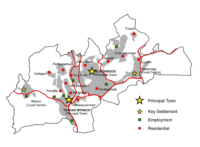
The NCC is a unique area of the coalfield. It comprises a contiguous area of urban development spanning the central Rhymney, Sirhowy and Ebbw Valleys where the topography favours east-west as well north-south movements. Thus the settlement pattern is more like that of a conventional urban conurbation rather than the traditional linear settlement structure of the typical Valleys town. The area, which stretches from Nelson in the west to Newbridge in the east and as far north as Bargoed, was home to 65,000 people in 2001 – a larger population than Cwmbran or Merthyr Tydfil.
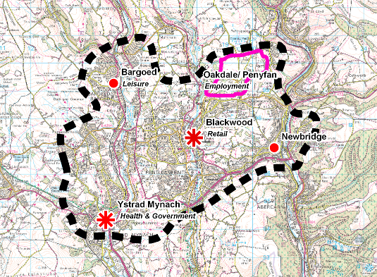
The NCC has two complementary centres at its core, namely Ystrad Mynach (containing the County Borough Council’s headquarters, a further education college and the site of a new local general hospital in the future) and Blackwood (the area’s major retail centre). It also includes one of the largest employment sites in the valleys, namely Oakdale Business Park.
The A472 forms the main east west highway along the southern edge of the NCC. From Newbridge to Blackwood the road is dual carriageway, as is the A469 between Caerphilly and Ystrad Mynach. The recently completed Sirhowy Enterprise Way links the major employment area at Oakdale / Penyfan to the A472 and also provides fast access to Blackwood Town Centre. Completion of the Angel Way Relief Road, which is being implemented as part of the Greater Bargoed Community Regeneration Scheme will ensure that the northern part of the NCC also benefits from good road access. Policies TR5andTR7 will enable improvements to be implemented to the road network that will increase accessibility levels in and around the NCC and improve the efficiency of the existing highway network. There are still concerns over the A472 link between Crown and Cwm Du roundabouts, through Maesycwmmer. The Council is investigating the potential and options for improvement along this section and, if appropriate, schemes will be identified in future revisions of the LDP as and when they arise.
Plan illustrating the Mid Valleys Urban Conurbation
The opening of the Ebbw Valley rail passenger service in 2008 means that both the eastern and western sides of the NCC have rail access to Cardiff. Improvements to the Rhymney Valley line have increased train frequencies to four an hour between Bargoed and Cardiff. These are significant developments in terms of facilitating sustainable development.
Oakdale Business Park together with Penyfan Industrial Estate comprises approximately a square kilometre (106 hectares) of existing and planned employment land. The Business Park has taken 6 years and over £10 million to reclaim, creating one of the largest employment plateaus in the South Wales Valleys. The site has already attracted major inward investment projects and proposals are in place for the future development of the site, providing a blend of properties to suit the needs of modern business. The success of the Business Park is critical in terms of ensuring economic prosperity for residents of the County Borough, and, in particular, in realising one of the main regional functions of the NCC – offering much needed employment opportunities to residents of the Heads of the Valleys Regeneration Area. Oakdale’s continued allocation for employment uses under Policy EM1, as well as the protection of a number of sites under Policy EM2, will aid the process of economic growth within the area.
Ystrad Mynach and Blackwood together with the Oakdale / Penyfan employment site and Bargoed in the Heads of the Valleys Regeneration area, form the core of the mid valleys conurbation. The principal towns in the conurbation have key roles as primary centres for the more deprived communities further north in the Heads of the Valleys Regeneration Area. They have the potential to connect the most deprived parts of the County Borough in the north with economic, leisure and cultural opportunities offered in the Mid Valleys area and in the south of the County Borough
Ystrad Mynachis well served in terms of the transportation network being located along the main Rhymney to Cardiff railway line, complemented by a Park and Ride facility. It is strategically located at the intersection of the A469 and A472 road corridors. Given its strategic location, the town has become the location for a number of vital public services including a college of further education and an area police station. Its role as the main centre for local government in the County Borough was enhanced with the completion of the new Council headquarters building at Tredomen. The most significant change will be the construction of a new local general hospital in 2010, which will serve thewhole County Borough. The presence of all these major services means that Ystrad Mynach is also a significant employment centre, a role that will increase over the Plan period.
Blackwoodis the principal town centre in the Mid Valleys East. The town has experienced significant levels of public and private investment in recent years with the development of substantial new retail units in both the north and south of the town. The town now contains more retail floorspace than any other town centre in the County Borough, including Caerphilly and as a result it is increasingly being recognised as an attractive sub regional shopping centre drawing people from a wide catchment area. CACI (leading marketing experts) estimate that the town’s annual turnover of comparison goods expenditure is approximately £46m and rank it as 22nd among Welsh retail centres.
The town is also easily accessible by car from Oakdale Business Park (the largest employment site in the County Borough) via the Chartist Bridge in the north. There is considerable potential therefore to exploit the relationship between the town and the business park.
Access to the town has improved dramatically with the development of the Sirhowy Enterprise Way and with the investment in the new Blackwood Bus Station. There is however a need to consider further improving the links to the town from the Heads of the Valleys Regeneration Area. There is a need to consider a more frequent public transport link to the Rhymney Valley Railway line at Ystrad Mynach and to consider new links to the Ebbw Valley Railway line at Newbridge. There is also a need to ensure that the strategic road network is upgraded at key locations, in order to ensure ease of movement between Blackwood and Ystrad Mynach. This all points to the need for a comprehensive public transport network for the mid valleys conurbation. Policy TR2 will allow for the provision of a new passenger service between Ystrad Mynach and Bedlinog, whilst Policies TR3andTR4 will enable new stations to be provided at Nelson and Crumlin and park and ride facilities to be developed at Pengam and Ystrad Mynach, thus optimising the improvements made to the rail network locally in recent times.
Blackwood will be critical to the success of the NCC in servicing the needs of the population in the immediate and wider area including the Heads of the Valleys Regeneration Area. The emphasis in Blackwood over the Plan period will be to build on its existing strengths as an excellent sub regional shopping centre and continue to improve the retail offer of the town, whilst developing a new role as an employment centre, particularly for office development. CM2.1, CM4.4 and CM5.2 are intended to encourage new retail, commercial leisure and office development within Blackwood, thus allowing for the creation of a diverse local economy.
Local centres in the NCC include Nelson in the west whose importance will grow for tourism and employment and Newbridge in the east, which became an important sustainable development location when its new railway station opened.
Nelsonis the most westerly settlement in the Mid Valleys West Community Plan area and is situated at a strategic location on the A472 approximately 2 miles from the Junction with the A470.
The village centre in Nelson offers a range of small shops and services to serve not only the Nelson area but also adjoining villages in Merthyr County Borough such as Treharris, Trelewis and Quakers Yard. Recent improvements to the central bus station have significantly improved the accessibility of the village centre to the surrounding area.
The national cycle route (47) runs through Nelson adjacent to the Wern Woodland Park and links the area to Penallta Community Park. Together these facilities provide a very attractive rural backdrop to Nelson. Wern Woodland Park also provides a valuable link for visitors to the area to a range of small shops and services within the historic village centre. Given the range of heritage and visitor attractions in the vicinity including Llancaiach Fawr living history museum, Nelson could have significant tourism potential. Policy TM1 allocates Llancaiach Fawr as a tourist facility, thus recognising its importance in this regard and to the local economy more generally.
A major employment site is proposed at Ty Du, on Nelson’s periphery. This land has been safeguarded for employment use for many years. Given the proximity of the Ty Du site to the prestige office complex in Ystrad Mynach an opportunity exists to promote Nelson as an excellent location for the development of innovative employment opportunities or as a centre for higher education facilities to complement the Tredomen Business Complex.
Newbridgeis situated at a strategic location at the crossroads of the A472 and the A467. The opening of the Ebbw Valley Railway and the new rail halt in Newbridge connect the town with the Southern Connections Corridor and with the Heads of the Valleys Regeneration Area in the north. The improvements to the public transport infrastructure, which includes a significant park and ride facility, will offer opportunities for economic diversification and improve the prospects of attracting new investment into the town.
The town centre currently offers a wide range of small independent shops and services to serve not only the Newbridge area but also the surrounding area. The emphasis in Newbridge over the Plan period will be to build on its existing strengths as an excellent local shopping centre and continue to improve the retail offer of the town, whilst diversifying the town centre through the redevelopment of key brownfield sites to provide appropriate opportunities for new economic activity, cultural facilities at the ‘Memo’, housing, public open space and car parking.
The former South Celynen Colliery site lies within the Southern Connections Corridor but also falls within the immediate Newbridge hinterland. Consequently, the redevelopment of this site for housing will serve to diversify the housing stock within the area and it is anticipated that this, together with the wide range of leisure and sporting activities available in the area will help to encourage young people to remain within Newbridge
Where there are suitable sites, residential development will be concentrated in the mid valleys conurbation, together with Nelson, Hengoed, Tir y Berth and Maesycwmmer, which have good access to the rail network. Limited housing development will also be allowed in the villages of Gelligaer and Trinant, where there is a need for a greater variety of housing to maintain the viability of these settlements
Policy HG1 addresses the issue of housing specifically, in terms of allocating land for development within those settlements mentioned. Clearly however, community facilities and open space are necessary requirements for creating sustainable settlements. Consequently, Policies CF1andLE1 will ensure that these facilities are in place.
The A472 is the primary east-west transport route in this area. The stretch between Newbridge and Blackwood is a modern dual carriageway but the remainder of the route is not up to the role that the strategy assigns to it. There are particular concerns over the link between the Crown and Cwm Du roundabouts, through Maesycwmmer. The Council is investigating the potential and options for improvement along this section and, if appropriate, schemes will be identified in future revisions of the LDP as and when they arise.
The A472 continues outside the County Borough first to Abercynon in the west and to Pontypool in the east. The efficiency of these single carriageway sections of the A472 should also be examined in the context of the South East Wales integrated city region.
The welcome reintroduction of passenger rail services on the Ebbw Valley line in 2008 will not disguise the fact that the service will have to develop a link with Newport and offer a greater frequency of trains and a greater number of stations if it is to provide a truly sustainable alternative to road traffic in that area.
AREA SPECIFIC POLICIES FOR THE NCC
SETTLEMENT IDENTITY
SI1 – Green Wedges
Green Wedges are identified and will be protected at the following locations:
| SI1.6 | Aberbargoed, Cefn Fforest and Pengam |
| SI1.7 | Penpedairheol, Gilfach and Tir y Berth |
| SI1.8 | Blackwood, Cwm Gelli and Cefn Fforest |
| SI1.9 | Blackwood, Oakdale and Penmaen |
| SI1.10 | Croespenmaen and Treowen |
| SI1.11 | West of Nelson |
| SI1.12 | Gelligaer, Penybryn and Penpedairheol |
| SI1.13 | Pengam, Blackwood and Pontllanfraith |
| SI1.14 | Newbridge and Abercarn |
| SI1.15 | Cefn Hengoed, Hengoed, Ystrad Mynach and Fleur de Lys |
| SI1.16 | Maesycwmmer, Pontllanfraith and Fleur de Lys |
| SI1.17 | Maesycwmmer and Ystrad Mynach |
The need to define and maintain open spaces between and within urban areas and settlements to prevent coalescence is considered important for the County Borough to protect the integrity of both the built and natural environment. Within green wedges, it is intended to resist any development proposal that would not maintain this open character.
The NCC has twelve green wedges, and all development proposals will only be considered where the use is either conducive to the existing character or enhances the character of the green wedge. A detailed description of the green wedge allocations can be found in Appendix 3.
CONSERVATION OF NATURAL HERITAGE
Special Landscape Areas (SLAs) are local non-statutory designations that seek to protect areas that exhibit distinctive landscape, historical, cultural, biodiversity and geological features and characteristics within the County Borough.They are locally important elements of the natural heritage of the rural and urban environments, and provide a living history of the evolution of the area’s landscape as well as cultural backdrop and visual setting. The designation of SLAs highlights the holistic consideration of the landscape, with emphasis placed on the ‘special’ nature of the distinctive landscape features and characteristics in these areas.
Two Special Landscape Areas have been identified in the NCC area. Theseareas will be protected from any development that would harm their distinctive features or characteristics. The policy is not designed to preclude development. However, an applicant will need to demonstrate that any development proposal will not have an unacceptable impact on the specific distinctive features or characteristics associated with the SLA.
LANDMAP is the national information system for taking landscape into account in decision-making. It separates landscape into five aspect areas: geological landscapes, visual and sensory, landscape habitats, cultural landscapes and the historic landscapes. The system allows information to be gathered, organised and evaluated within a nationally consistent data set.All of the SLAs have been identified using LANDMAP information and SLA designation methodology. This recognises that an SLA may include small parts of the local landscape that do not display the same level of landscape importance. A detailed description of the SLA designations can be found in Appendix 1, which provides a breakdown of the distinctive landscape features and characteristics within each SLA.
Visually Important Local Landscapes (VILLs) are non-statutory designations that seek to protect the distinctive features or characteristics of the visual and sensory landscape of the County Borough and how we perceive and respond to the landscape around us. VILLS have been identified using only the visual and sensory layer of LANDMAP. The NCC has one Visually Important Landscape.
Development will only be permitted where it conserves and, where appropriate, enhances the distinctive visual and sensory landscape features or characteristics of the VILL. Development proposals should demonstrate that these features of the visual and sensory LANDMAP aspect layer are conserved and, where appropriate enhanced for the benefit of the visual landscape. A detailed description of the VILL designations can be found in Appendix 2, which provides a summary of the distinctive visual and sensory landscape features and characteristics within the VILL
NH3 – Sites of Importance for Nature Conservation (SINCs)
Sites of Importance for Nature Conservation are identified and will be protected at:
| NH3.1 | River Rhymney |
| NH3.11 | River Sirhowy |
| NH3.12 | River Ebbw |
| NH3.41 | Nant-Gau and Darran Woodlands, North of Oakdale |
| NH3.42 | Caeau Cwm-Corrwg, North of Oakdale |
| NH3.43 | Gwerthnor-Isaf Wood, South of Gilfach |
| NH3.44 | Britannia Wood, South of Aberbargoed |
| NH3.45 | Ty’n-y-Pwll Wood and Tip, South of Britannia |
| NH3.46 | Mynydd Pen-y-Fan, South East of Manmoel |
| NH3.47 | Pen-y-Fan-Fach Grasslands, Glandwr |
| NH3.48 | Nant Gwynt Woodland, Glandwr |
| NH3.49 | Pen-y-Fan Pond and Meadows, West of Pentwyn |
| NH3.50 | Coed Trinant, East of Pentwyn |
| NH3.51 | Pentwyn Fields, Pentwyn |
| NH3.52 | Pottery Road Slopes, East of Gelligaer |
| NH3.53 | Waun Rydd, Gelligaer |
| NH3.54 | Land South of Gelligaer Infants School, Gelligaer |
| NH3.55 | Cwm Afon Railway Line, West of Nelson |
| NH3.56 | Cwm Afon, West of Nelson |
| NH3.57 | Wern Woodland, Nelson |
| NH3.58 | Brooklands Marsh, North of Nelson |
| NH3.59 | Tredomen Tip Ponds, Nelson |
| NH3.60 | Llancaiach-Fawr Meadows, Llancaiach |
| NH3.61 | Coed Gelliau’r-Gwellt, East of Llancaiach |
| NH3.62 | Nant Caeach, North of Llancaiach |
| NH3.63 | Cefn Hengoed Hillside, North of Hengoed |
| NH3.64 | Penallta Meadows, West of Hengoed |
| NH3.65 | Gelligaer Court Meadows, North of Penpedairheol |
| NH3.66 | Tir Jack Slopes, East of Penpedairheol |
| NH3.67 | Upper Trelyn Woodland, South of Pengam |
| NH3.68 | Blackwood Golf Club Woodland, Cefn Fforest |
| NH3.69 | Coed y Gelli, North of Cefn Fforest |
| NH3.70 | Cwm Gelli Wood and Meadow, North of Cefn Fforest |
| NH3.71 | Blackwood Riverside Woodlands, North East of Blackwood |
| NH3.72 | Penmaen Carr, East of Blackwood |
| NH3.73 | Coed Duon, Blackwood |
| NH3.74 | Cefn Fforest Eco Park, Blackwood |
| NH3.75 | Penllwyn Woodlands, Pontllanfraith |
| NH3.76 | Nant yr Odyn, East of Pontllanfraith |
| NH3.77 | Crown Estate Meadows, Pontllanfraith |
| NH3.78 | Crown Roundabout Marsh, Pontllanfraith |
| NH3.79 | Trelyn Woodland and Meadow, Pontllanfraith |
| NH3.80 | Enterprise Way Grasslands, Pontllanfraith |
| NH3.81 | Coed Penallta and Railway Line, Ystrad Mynach |
| NH3.82 | Tir-Twyn Woodlands, Ystrad Mynach |
| NH3.83 | Coedcae Mawr, Ystrad Mynach |
| NH3.84 | Maesycwmmer Woodland and Meadows, Maesycwmmer |
| NH3.85 | Bryn Ysgafn Meadow, Fleur De Lys |
| NH3.86 | Victoria Road Slopes, Fleur De Lys |
| NH3.87 | Penmaen Woodlands, Penmaen |
| NH3.88 | Cwm Dows Valley, East of Penmaen |
| NH3.89 | Coed Cwm Philkins, East of Penmaen |
| NH3.90 | Cyncoed Fields, East of Penmaen |
| NH3.91 | Pentwyn-Isaf Woodlands, Pentwynmawr |
| NH3.92 | Glan-Brynar Woodlands, Pentwynmawr |
| NH3.93 | Greenlands Meadow, Pentwynmawr |
| NH3.94 | Ton-y-Pistyll Fields, Pentwynmawr |
| NH3.95 | Valentec Nature Reserve, North of Croespenmaen |
| NH3.96 | Pen- Rhiw Bengi Marsh, Oakdale |
| NH3.97 | Nant Philkins Fields, Oakdale |
| NH3.98 | Remploy Factory Grounds, Oakdale |
| NH3.99 | Penyfan Industrial Estate Woodland, Oakdale |
| NH3.100 | Pant Glas Meadow, Trinant |
| NH3.101 | Crumlin Old Farm Meadows, Crumlin |
| NH3.102 | Cwm Kendon, Crumlin |
| NH3.103 | Llanerch-Isaf Woodland, Crumlin |
| NH3.104 | Coed Goferau, Crumlin |
| NH3.105 | Pontbren, North of Crumlin |
| NH3.106 | Coedcae Watkin Dafydd, East of Crumlin |
| NH3.107 | Ty-Mawr Wood, Rhiw |
| NH3.108 | Pant-Ysgawen Fields, Treowen |
| NH3.109 | Pennar- Ganol, South of Newbridge |
| NH3.110 | Pen-Rhiw-Bica, South of Newbridge |
| NH3.111 | Coed Gawni, East of Newbridge |
| NH3.112 | Coed Cil-Lonydd, East of Newbridge |
| NH3.113 | Mynydd Maen, East of Newbridge |
| NH3.114 | Coedcae Newydd, Gelligroes |
| NH3.115 | Ty Bach Marsh, East of Wyllie |
| NH3.116 | Heol-Ddu Woodlands, Wyllie |
| NH3.117 | Llanbradach Fawr Woodlands, North of Llanbradach |
| NH3.118 | Mynydd Bach Slopes, East of Llanbradach |
| NH3.119 | Coed Mawr, North of Llanbradach |
| NH3.120 | Mynydd Eglwysilan, North of Senghenydd |
| NH3.121 | Land at Tair Waun Uchaf Isaf and Cwmheldeg Farm, Senghenydd |
| NH3.122 | Nant Cae-Dudwg Mire, North of Senghenydd |
Sites of Importance for Nature Conservation (SINCs) are an important biodiversity resource covering significant areas of priority habitats and species. Designations are based on objective scientific criteria to accord with the (developing) Wales-wide guidelines. This policy applies to all sites that meet the criteria for designation
Development will normally be permitted where it would not cause unacceptable harm to the particular features of the SINC. Where harm is unavoidable it should be minimised by effective mitigation measures to ensure that there is no reduction in the overall nature conservation value of the area or feature. Where this is not possible, compensation measures designed to conserve, enhance and manage locally distinctive natural habitats and species should be provided, including for example details of restoration and reclamation schemes. A description of thedesignated SINCs can be found in Appendix 4.
MINERALS
The development restrictions associated with these zones are described in PolicyCW23 in section two of the Plan.
The Coal TAN (MTAN 2 - Coal)requires local planning authorities to safeguard coal resources for the future. The safeguarding of the resource does not indicate any presumption in favour of working but it prevents the sterilisation of the resource by other development.
Minerals Technical Advice Note 1 - Aggregates requires local planning authorities to safeguard land-based resources of sand and gravel as an alternative to marine supply
Background Paper 5 provides detailed information on the coal and sand and gravel resources within the Northern Connections Corridor.
HOUSING
HG1 – Allocated Housing Sites
Land has been allocated for housing across the Northern Connections Corridor as follows:
| Site Name | Settlement | Size (Ha) | Units | |
| HG1.23 | Land within curtilage of the Pentwyn Inn + | Trinant | 0.4 | 19 |
| HG1.24 | Land off Brynhoward Terrace | Oakdale | 2.20 | 77 |
| HG1.25 | Allotment Garden, Llwyn on Lane + | Oakdale | 1.37 | 49 |
| HG1.26 | Blackwood Ambulance Station | Blackwood | 0.68 | 24 |
| HG1.27 | Pencoed Avenue + | Cefn Fforest | 1.87 | 65 |
| HG1.28 | Land east of Bryn Road | Cefn Fforest | 0.68 | 24 |
| HG1.29 | South of Thorncombe Road + | Blackwood | 0.34 | 12 |
| HG1.30 | Land at Hawtin Park | Pontllanfraith | 5.55 | 194 |
| HG1.31 | Oak Terrace | Fleur-de-Lys | 0.69 | 21 |
| HG1.32 | Tir-y-berth | Hengoed | 4.95 | 173 |
| HG1.33 | Penallta Colliery + | Ystrad Mynach | 27.18 | 689 |
| HG1.34 | Penallta Yard + | Ystrad Mynach | 0.29 | 10 |
| HG1.35 | Land at New Road | Ystrad Mynach | 0.54 | 18 |
| HG1.36 | Land off Valley View + | Hengoed | 1.46 | 31 |
| HG1.37 | Greenhill Primary School | Gelligaer | 2.8 | 32 |
| HG1.38 | Land to the east of Handball Court | Nelson | 3.36 | 90 |
| HG1.39 | Former Cattle Market Site + | Nelson | 0.62 | 12 |
| HG1.40 | Land at Gellideg Heights | Maesycwmmer | 3.91 | 137 |
| HG1.41 | Land at Ty Pwll + | Pantside | 0.64 | 16 |
| HG1.42 | Land west of Old Pant Road | Pantside | 2.2 | 56 |
| HG1.43 | The Stores, Albertina Road + | Newbridge | 0.41 | 10 |
| HG1.44 | Land at Fields Park | Newbridge | 2.30 | 80 |
| HG1.45 | Pennar Lane + | Newbridge | 4.00 | 63 |
| HG1.46 | Chris Bowen Garage + | Newbridge | 0.08 | 16 |
| TOTAL | 68.52 | 1,918 |
+ The site had planning consent as of 1st April 2007
The allocation of sites for residential development is important in ensuring sufficient land is available to meet future population requirements. In the NCC a total of 1,918 units have been allocated across a range of sites in order to reflect the role and functions of settlements. In this area, 68% of dwellings are allocated on brownfield sites
Land allocated under this policy includes:
- Sites with planning consent for housing or for a mix of uses incorporating housing as of 1st April 2007 (in some cases subject to the signing of a Section 106 Agreement).
- New sites that have been identified as suitable for residential development or for a mix of uses including housing as a result of a robust candidate site assessment process.
Detailed descriptions of these site allocations can be found in Appendix 7. In addition, surveys and further information that will be required to be submitted as part of future planning applications is set out in Appendix 8.
A proportion of affordable housing will be required to be provided on sites allocated under this policy in accordance with Policy CW11 where there is evidence of need
The proposed number of units identified for each site is indicative and higher or lower densities may be acceptable where the proposed development addresses other policy considerations including design, sustainability, and comprehensive development.
EMPLOYMENT
EM1 – Employment Allocations
The following sites are allocated for employment uses, in line with their status in the employment hierarchy:
| Site Name | Settlement | Size (Ha) | Type | |
| EM1.2 | Ty Du | Nelson | 18.8 | Business park |
| EM1.3 | Plateau 1, Oakdale Business Park | Oakdale | 30.2 | Primary site |
| EM1.4 | Plateau 2, Oakdale Business Park + | Oakdale | 7.0 | Primary site |
| EM1.5 | Plateau 3, Oakdale Business Park | Oakdale | 3.4 | Primary site |
| EM1.6 | Plateau 4, Oakdale Business Park + | Oakdale | 4.3 | Primary site |
| EM1.7 | Hawtin Park north + | Gellihaf | 4.5 | Primary site |
| EM1.8 | Hawtin Park south | Gellihaf | 8.8 | Primary site |
| EM1.9 | Dyffryn Business Park north | Ystrad Mynach | 4.9 | Primary site |
| EM1.10 | Dyffryn Business Park south | Ystrad Mynach | 6.3 | Primary site |
| EM1.11 | Penallta Extension + | Hengoed | 1.6 | Secondary site |
+ P/P 1st April 2007
The business park allocation at Nelson is designated solely for class B1 use which equates to office-based development. This is predominantly concerned with the service, commercial and financial sectors. The latter two particularly have an important role to play in terms of fostering entrepreneurialism and developing an enterprise culture, factors which are of key importance if the local, and indeed regional, economy is to grow in a sustainable fashion.
The designated primary sites currently house a mixture of Use Classes, and as such, they are considered appropriate for Use Classes B1, B2 and B8, namely offices, light and general industry, and warehousing uses. Proposals for the development of the vacant land within these sites are also expected to accord with those uses.
The site described as the Penallta Extension is considered suitable for appropriate sui generis uses in addition to Use ClassesB1, B2 and B8. Sui generis uses can play an important role in the economic fabric of the County Borough, although it is necessary to ensure that they complement and support other, neighbouring uses, rather than act in competition or be of detriment to them.
A detailed description of these site allocations can be found in Appendix 9.
EM2 – Employment Sites Protection
The following sites are protected for employment uses, in line with their status in the employment hierarchy:
| EM2.7 | Dwr Cymru Welsh Water Offices, Nelson | Business park |
| EM2.8 | Tredomen Park, Ystrad Mynach | Business park |
| EM2.9 | Plateau 2, Oakdale Business Park | Primary site |
| EM2.10 | Penyfan, Croespenmaen | Primary site |
| EM2.11 | North Celynen, Newbridge (south of site access road) | Primary site |
| EM2.12 | Hawtin Park, Gellihaf | Primary site |
| EM2.13 | Dyffryn Business Park | Primary site |
| EM2.14 | North Celynen, Newbridge (north of site access road) | Secondary site |
| EM2.15 | Croespenmaen | Secondary site |
| EM2.16 | Britannia, Pengam | Secondary site |
| EM2.17 | St. David’s, Pengam | Secondary site |
| EM2.18 | New Road, Tiryberth | Secondary site |
| EM2.19 | Penallta | Secondary site |
| EM2.20 | Newbridge Road, Pontllanfraith | Secondary site |
| EM2.21 | Tram Road, Pontllanfraith | Secondary site |
| EM2.22 | Switchgear, Pontllanfraith | Secondary site |
| EM2.23 | Penmaen | Secondary site |
| EM2.24 | Woodfieldside, Penmaen | Secondary site |
In addition to land allocated for future employment development (Policy EM1), a number of sites exist within the County Borough that already possess functioning employment uses. Such sites will be protected from development outside of those use classes indicated by the relevant categorisation (e.g. use class B1 only for Business Parks). This protection policy is intended to operate in tandem with Policy CW13 in this regard.
Tredomen Business Park is ideally suited as a location for high-quality, office-based uses, which are geared towards the growth of innovation and enterprise within the local economy. This is a key location in which to develop the concept of partnership working as a means of providing economic growth, particularly between the public and private sectors, given the presence of the Council’s new headquarters building. As such this site is to be protected solely for Use ClassB1. The designated primary sites currently house a mixture of use classes, and as such, are considered appropriate for Use ClassB1, B2 and B8. On the defined secondary sites this protection policy allows the development of sui generis uses as well. Sui generis uses can play an important role in the economic fabric of the County Borough, although it is necessary to ensure that they complement and support other, neighbouring uses, rather than act in competition or be detrimental to them.
COMMERCIAL DEVELOPMENT
This policy defines the boundaries of the two Principal Town Centres within the NCC. The Principal Towns possess a multi functional role in their delivery of services to the public within their catchment area. They are the main shopping centres, but also commercial service centres, community service centres, and centres for commercial leisure activities too. As such they are also major employers as well. Therefore, retail policies have been formulated which aim at protecting and enhancing their retail vitality and viability. This policy is intended to operate in tandem with the requirements of Policy CW14.
The main thrust of the retail strategy is to continue to expand overall retail provision in the County Borough through the growth of high quality shopping centres which retain the best existing features combined with provision for new shopping investments and environmental enhancement. Therefore, policies seek to focus retail developments within existing shopping centres and defined edge of centre locations to accommodate specific types of stores.
Blackwood in the NCC (and Caerphilly in the Southern Connections Corridor), are by far the largest centres in terms of retail floorspace, service provision, and commercial leisure facilities, being an order of magnitude greater than the other three principal centres. Blackwood has also recently accommodated significant further retail development in North Blackwood and at Blackwood Gate. Therefore, the aim in both towns is geared more to maintaining and enhancing this improvement in their status, viability and vitality. Blackwood is also a centre where one would expect new office developments to locate.
Although Ystrad Mynach contains both a Tesco superstore and a Lidl, it is more important for its office and health roles. It houses the main headquarters of the Council and a new hospital will soon be under construction in the town to serve the NCC and beyond. However, part of the town is subject to a flood risk designation. The detail of future development proposals within the flood risk area will need to address this issue.
These two defined Principal Town Centre boundaries are shown on the Proposals Map and are also shown on larger scale plans in Appendix 11.
Blackwood is one of the largest centres in terms of retail floorspace, service provision, and commercial leisure facilities. It has also recently accommodated significant further retail development at Blackwood Gate.
This particular Retail Warehouse Park has been given defined boundaries in order to promote its development in advance of sites in other less appropriate out-of-centre locations. It was chosen to complement Blackwood’s existing retail offer. The aim to give it development priority is, therefore, both sustainable and supportive of the aims of the retail strategy. This policy is intended to operate in tandem with the requirements of Policy CW17
The defined boundary of the Blackwood Gate Retail Warehouse Park is shown on the Proposals Map and is also shown on a larger scale plan in Appendix 11.
The boundary of the Blackwood Primary Retail Area has been tightly drawn in order to permit the accommodation of new A2 and A3 uses within the large remaining portion of the retail centre. Therefore, the policy does not limit these uses, because they also have their role to play in creating a vibrant town centre, but it lessens their adverse cumulative impact in the shopping core. This policy is intended to operate in tandem with the requirements of Policy CW14.
The boundary of the Blackwood Primary Retail Area is shown on the Proposals Map. It is also shown on a larger scale plan in Appendix 11.
CM4 – Principal Town and Local Centre Development Sites
The following Principal Town and Local Centresites are allocated for retail, commercial leisure, and office developments:
| Site Name | Settlement | Size (Ha) | Proposal Type | |
| CM4.4 | Car Park Site, Rear of High Street | Blackwood | 0.1 | Offices |
| CM4.5 | Gateway Site | Newbridge | 0.3 | Offices |
| CM4.6 | Penallta Colliery | Ystrad Mynach | 2.0 | Retail, Offices |
A detailed description of this site allocation can be found in Appendix 10.
A Commercial Opportunity Area has been identified for the Principal Town of Blackwood where office development might prove particularly beneficial. However, this will not preclude such proposals anywhere else inside the designated town centres apart from within the Primary Areas. This policy initiative aims to provide yet another significant set of opportunities to drive further economic growth in the County Borough. The boundary of the Blackwood Commercial Opportunity Area is shown on the Proposals Map. It is also shown on a larger scale plan in Appendix 11.
COMMUNITY FACILITIES
CF1 – Community Facilities
The following sites are allocated for new community facilities:
| CF1.12 |
East of Gelligaer Cemetery, Gelligaer – Cemetery extension |
| CF1.13 |
Greenhill Primary School, Gelligaer – New school |
| CF1.14 |
Maesglas School, Gelligaer – GP surgery |
| CF1.15 |
Ysgol Penalltau, Ystrad Mynach – New school |
| CF1.16 |
Oakfield Street, Ystrad Mynach – GP surgery |
| CF1.17 |
Ystrad Fawr, Ystrad Mynach – Local General Hospital |
| CF1.18 |
Memorial Hall and Institute, Newbridge – Library |
| CF1.19 |
Pantside, Newbridge –Community centre |
| CF1.20 |
Adjacent to Recreation Ground, Hafodyrynys –Community centre |
Detailed descriptions of these site allocations can be found in Appendix 14.
LEISURE
LE1 – Protection of Formal Open Spaces
Land is protected for open space and parkland uses at:
| LE1.6 |
The Circle, Oakdale |
| LE1.7 |
Recreation Ground, Oakdale |
| LE1.8 |
Welfare Ground, Cefn Fforest |
| LE1.9 |
Sir Harold Finch Memorial Park, Pontllanfraith |
| LE1.10 |
Libanus Fields, Pontllanfraith |
| LE1.11 |
The Bryn, Pontllanfraith |
| LE1.12 |
Islwyn Park, Pontllanfraith |
| LE1.13 |
Caertwmpyn Park, Newbridge |
| LE1.14 |
Newbridge Rugby Ground, Newbridge |
| LE1.15 |
Trelyn Park, Fleur De Lys |
| LE1.16 |
Wern Crescent, Nelson |
| LE1.17 |
Institute Field, Hengoed |
| LE1.18 |
Maesycwmmer Park, Maesycwmmer |
| LE1.19 |
Ystrad Mynach Park, Ystrad Mynach |
Formal parks and gardens are attractive civic spaces for public enjoyment and should be protected as such. Incremental reductions in their boundaries in favour of built development should be avoided in order that they are present for future generations to experience.
Many parks are laid out with attractions such as floral displays, plant growing, sports pitches, children’s playgrounds and ornamental water features. Whilst it is important to incorporate some flexibility for selective development that will consolidate these uses such as shelters, pavilions and storage buildings, it is vital that the leisure aspect is enhanced.
Country parks are large scale, less formal facilities that offer a valuable resource for recreational and tourism activities within a rural setting, close to the County Borough’s main centres of population. In order to recognise their contribution to the landscape as tourism attractions in their own right and to ensure that they continue to serve this purpose, the Plandefines their boundaries so that they can be protected from any inappropriate development.
A number have been developed on land that was once covered by heavy industry but now reclaimed, with all offering a range of recreational activities. Already there are cycle routes identified in the County Borough, and the varied parks along the Rhymney, Sirhowy and Ebbw Valleys appear to offer potential for linking these. This will feed into the loops and links network that will in turn form part of the Valleys Regional Park.
Playing pitches are an integral part of most communities’ formal recreation provision. In measuring the quantity of facilities against the National Playing Fields Association ‘Six Acre Standard’, a shortage of playing pitches has been identified within the County Borough.
Whilst this reflects a national decline in provision, the NPFA standards are still intended as a firm aspiration for local authority land use policies in order that the decline can be arrested and reversed. As such, the former colliery waste tip has been identified for a new playing pitch development. Allotment gardening is a popular leisure pastime with an increased interest in the pursuit in recent years. As such, allotments are becoming increasingly in demand and suitable locations are required to be protected for this purpose throughout the County Borough, including land off Penallta Road, Ystrad Mynach.
LE5 – Protection of Informal Open Spaces
Land is protected for informal recreation and community uses at:
| LE5.4 |
Former Oakdale Colliery, Oakdale |
| LE5.5 |
Adjacent to Vernon Place, Croespenmaen |
| LE5.6 |
Rear of Oakdale Terrace, Penmaen |
| LE5.7 | Upper Trelyn, Blackwood |
| LE5.8 |
Trelyn Farm, Blackwood |
| LE5.9 |
South of Islwyn Park, Pontllanfraith |
| LE5.10 |
South of Leisure Centre, Newbridge |
| LE5.11 |
Pantside, Newbridge |
| LE5.12 |
Ynys Las, Nelson |
| LE5.13 |
Adjacent to River Rhymney, Tiryberth |
| LE5.14 |
Adjacent to River Rhymney, Hengoed |
| LE5.15 |
South of Brynawel Road, Hengoed |
| LE5.16 |
Maesycwmmer Meadows, Maesycwmmer |
Open spaces of a less formal character are often vital elements in the suburban landscape, offering a visually attractive haven for wildlife. This can often involve the community in ownership and conservation projects. These areas may often be used for walking and can in some instances offer informal enjoyment for cyclists passing through the area.
TOURISM
Tourism is a significant contributor to the County Borough’s economy, with attractions such as Llancaiach Fawr Manor House forming part of a network of historic buildings and landscapes. Continuing their success is a prime objective of any tourism strategy, and developing other attractions is an effective means of promoting regeneration and increasing economic activity in specific locations.
A linear route that can be developed along a network of informal green spaces is the Rhymney Riverside Walk. This currently follows the course of the River Rhymney southwards from Rhymney and is complete until the Tir-y-berth to Hengoed, Maesycwmmer and Ystrad Mynach lengths in the Northern Connections Corridor, parts of which are missing. It thereafter links settlements in the Southern Connections Corridor to Machen, Draethen and Cefn Mably, where it also requires further development. The walk comprises of landscaped walkways with observation points maximising use of the river as a resource for tourists. It will benefit from protection in order to complete this long distance footpath route.
TRANSPORTATION
TR1 – Cycle Routes
Land will be safeguarded to facilitate the following improvements to the cycle route network:
| TR1.8 | Rhymney Valley Linear Cycle Route - Heads of the Valleys to Bedwas / Caerphilly, Northern |
| TR1.9 | Network Links from Blackwood / Pontllanfraith |
| TR1.10 | Newbridge / Crumlin to Crosskeys and Sirhowy Valley / Pontllanfraith Cycle Link |
| TR1.11 | Local Links from Crumlin |
| TR1.12 | Local Link from Penallta to Ystrad Mynach |
A key factor in delivering more sustainable transport is realising a significant increase in the number of shorter trips by walking and cycling. The provision of a high quality strategic and local network of dedicated routes for these modes is an essential element in realising this growth
The specific route alignments for the above improvements have yet to be considered in detail and the schemes are at differing stages of development. Indicative route alignments are shown on the LDP Proposals Map and only represent the general direction of the route. The indicative alignments on the Proposals Map, therefore, are not prescriptive.
In addition to the above potential schemes, Safe Routes to Stations and Safe Routes in Communities Schemes will also be prioritised.
The proposed cycle routes within the Northern Connections Corridor will promote regeneration and sustainability, encourage healthier lifestyles and increased physical activity, and contribute to the economic prosperity of the area.
The routes of former railway lines which have potential for transport related development will be safeguarded, particularly those which facilitate walking, cycling rail freight or passenger movements
Design layout for residential, employment, retail, leisure and other developments will be expected to incorporate provision for walking and cycling and where possible links / access to the developing walking and cycling networks.
The Cwmbargoed line, whilst operating as a freight line for the Ffos-Y-Fran mineral extraction works, remains as the last significant rail line within the County Borough that does not have passenger services. The Cwmbargoed line links Nelson to Ystrad Mynach and the services on the Rhymney Valley line.
The reinstatement of this line for passenger services would facilitate movements to and from Nelson, particularly for the proposed employment uses at Ty Du. Currently, the reinstatement of the line does not form part of any current transport programme, but the Council will continue to pursue this through all possible avenues.
The Council is seeking a station at Nelson as part of any future development of the Cwmbargoed line for passenger services. This new station would provide a link to Ystrad Mynach and rail services on the Rhymney Valley line and provide a service for the proposed employment uses at the Ty Du site.
The reopening of the Ebbw Valley line for passenger services provides an excellent opportunity to increase rail patronage in the County Borough. Whilst the new passenger services are welcome, the Council is still seeking the establishment of a station at Crumlin, which would assist in providing public transport to the main employment centre at Oakdale.
The specific land requirements for the new stations have yet to be considered in detail and the schemes are at differing stages of development. The LDP Proposals Map identifies the general locations that relate to the proposals, but does not seek to identify specific sites for the proposals. As such the allocations are indicative and should not be considered to be prescriptive.
The recent and ongoing frequency and capacity improvements on the Rhymney Valley line, in conjunction with the opening of the Ebbw Valley line for passenger services, provides an excellent opportunity to increase rail patronage in the County Borough. The provision of park and ride facilities at stations increases access to the rail network and encourages car users to change to rail for a significant part of their journey. The expansion of park and ride facilities at Pengam will increase the scope for the public, particularly commuters, to access and utilise the improved rail services
The specific land requirements for the Pengam improvement has yet to be considered in detail and the scheme is at an early stage of development. The LDP Proposals Map identifies the location that relates to the proposal, but does not seek to identify the land required. As such the allocation is indicative and should not be considered to be prescriptive
TR5 – Transport Improvement Schemes – Northern Connections Corridor
The following strategic network improvements have been identified in respect of a Northern Connections Corridor Obligation:
| TR5.1 | A467 Newbridge to Crosskeys |
| TR5.2 | A467 Newbridge to Crumlin |
| TR5.3 | A472 Ystrad Mynach to Nelson |
| TR5.4 | Newbridge Interchange |
| TR5.5 | A472 Crown Roundabout to Cwm Du Roundabout |
The LDP will accommodate an increase in population during the Plan period and has allocated sites to cater for the housing, employment and other needs accordingly. This development will realise significant increases in traffic on the transport network of the County Borough, which will result in increased congestion. As a result general areas of improvement to the strategic network, which will seek to alleviate the cumulative impact of these developments, have been identified. Further work will be undertaken to consider the environmental, social and economic impacts of development in the area and appropriate schemes will be progressed as part of the development of a Northern Connections Corridor Obligation.
In order to facilitate the hospital development in Ystrad Mynach, improvements to the Cwm Du Junction (junction of A472 and A469) are required due to forecasted increased traffic flows. These works affect the roundabout, and sections of the A469 and A472, including the light controlled junction at Maesycwmmer.
The specific route alignment for the above proposal has yet to be considered in detail. The LDP Proposals Map identifies a general direction for the route, but does not identify the land required for the proposal. As such the allocation should be considered as being indicative and not conveying any prescription of the route that will be determined by further work.
IMPLEMENTATION AND DELIVERY – Northern Connections Corridor
Although the private sector has shown a high level of interest in investing in this area in the past, there are relatively few new development sites proposed in the LDP compared to those that already have planning consent. This means that contributions from future planning obligations will be limited and the public sector will still be responsible for most infrastructure provision in this corridor.
This area qualifies for European Convergence Funding (2007-2013) but is not a priority location within that programme as it contains relatively few very deprived settlements. It does however contain the County Borough’s principal new employment sites, which may be expected to receive strong financial support.
Risks
The major new hospital site is dependent on improvements to the A472 at Maesycwmmer but both the hospital and associated highway improvements are fully funded.
There are no other allocations in this area that are dependent on a key element of infrastructure for their implementation, although in general, infrastructure provision will be expected to keep pace with development.
STRATEGY AREA 3: SOUTHERN CONNECTIONS CORRIDOR (SCC)
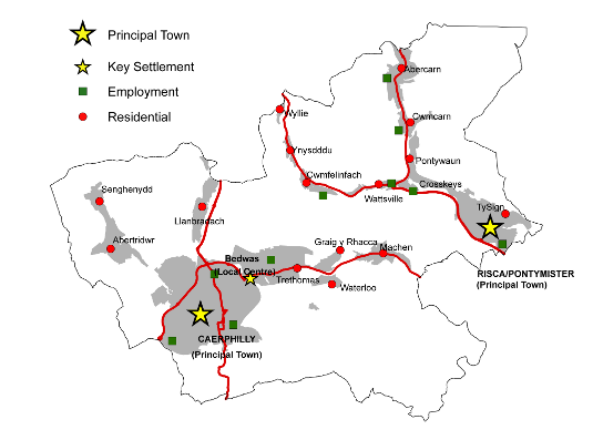
SUB-REGIONAL CONTEXT
The Principal Towns of Caerphilly and Risca / Pontymister lie in separate river valleys, and therefore although both are part of the Southern Connections Corridor (SCC) they do not form a single conurbation like the key centres in the Northern Connections Corridor.
As Cardiff and Newport have become more successful, Caerphilly and to a lesser extent Risca have experienced increased development pressure. Significant levels of new development have occurred, particularly in the Caerphilly Basin as a result in recent years.
Whilst there is a need for Risca / Pontymister and Caerphilly to continue to capitalise on their proximity to Newport and Cardiff respectively and exploit the economic opportunities that this can bring, there is also a need to ensure that these areas do not ‘over-heat’ to the extent that economic progress is outweighed by negative environmental effects of over development. The priority and emphasis in this area will be on the redevelopment of existing sites and not on the release of any substantial new greenfield land. The Plan will need to ensure, however, that all the brownfield sites are not developed for housing to the detriment of the important employment, retailing and service roles played by the local centres.
Of the smaller settlements in the SCC, Bedwas / Trethomas is by far the largest (population 8,000) and has a more local role in employment and cultural provision in the Caerphilly Basin.
The Caerphilly Basin is the only substantial district of the County Borough not to have a country park. In view of the importance of developing the Valleys Regional Park during the Plan period, the County Borough Council will investigate the possibility for creating a country park in the Caerphilly Basin area, linked into the emerging cyclepath network and complementing the already strong tourism offer of Caerphilly Castle
LOWER ISLWYN AREA
Risca / Pontymister is the main centre for services in this district. The College of Further Education at Crosskeys serves an even wider area. The commercial function of the area is largely overshadowed by its close proximity to Newport and to some extent Blackwood. However the possibility exists to restructure the town centre to attract inward investment and improve the attractiveness of the area to residents and visitors alike. CM4.7, CM4.8andCM4.9 allocate land for retail developments within Risca / Pontymister, thus aiding the creation of a diverse local economy.
Scope exists to exploit the opportunities afforded by the re-opening of the Ebbw Valley railway line and the restoration of the canal. An opportunity exists to provide for new mixed-use development comprising employment, retailing and housing development on brownfield land adjacent to the River Ebbw. Care will need to be taken however as large areas of the valley bottom are identified as being at risk from flooding.
The A467 is the main route that links Abercarn and Cwmcarn to Risca, the M4 and Newport in the South. The A4048 links the Lower Sirhowy Valley to the nearby subregionalcentre of Blackwood and to employment opportunities in the NCC. The opening of the Ebbw Valley passenger line with stations at Abercarn, Cwmcarn, Crosskeys and Pontymister will improve public transport access to/from Newbridge in the north and to/from Risca, Cardiff (and eventually Newport) in the south.
Abercarn, Cwmcarn, Ty Sign, Pontywaun, Cwmfelinfach, Wattsville andYnysddu are primarily residential villages, though most also have an employment role.
The surrounding countryside includes the Cwmcarn Forest Drive and the Sirhowy Country Park making the district significant for tourism and recreation. This role is planned to increase in the context of the Valleys Regional Park.
CAERPHILLY BASIN
Caerphilly is the Principal Town in the Caerphilly Basin and it plays an important subregional role in relation to shopping, employment, leisure, and tourism. Proposals for development will be welcomed which support this role in a way that is compatible with the strategy and policies of the Plan. Appropriate allocations will be made within settlement boundaries to provide for this. As a significant employment location there will be a need to allocate land for employment use within the Caerphilly Basin. However the priority and emphasis will be to redevelop existing sites, including the town centre, to enhance its important role as a retail and employment hub.
Caerphilly town centre is an important retail area and offers an alternative to Cardiff for regular shopping needs. CM2.2, CM4.10, CM4.11, CM4.12, CM4.13, CM4.14, andCM5.3 encourage the development of a range of complementary uses, namely retailing, commercial leisure and office development. Policies EM1andEM2will allocate and protect, as appropriate, suitable employment sites. Collectively, these policies will ensure the creation of a diverse local economy for the benefit of the County Borough.
Bedwas has maintained a strong industrial base and the village accommodates two large successful industrial estates at Bedwas House and Pant Glas totalling approximately 61hectares. The area will continue to provide such sites, via Policies EM1and EM2.
Proposals to enhance Bedwas Workmen’s Hall and improve the surrounding area are part of a developing role for the village in the provision of cultural and recreational facilities for the Caerphilly Basin. The area could have tourism potential given its close proximity to Caerphilly Castle and to Caerphilly Town Centre.
The redevelopment of Bedwas Colliery will have a significant impact on the future role and function of Bedwas and Trethomas in this regard. This large brownfield site offers an opportunity to expand the residential role of Bedwas and also provide associated community and leisure facilities to further increase the attractiveness of the area. The redevelopment of the site would require substantial highway improvements to be undertaken in the area. It is envisaged that a new access road will be provided under Policy TR7.
There is also an opportunity to exploit the village’s riverside location by developing a riverside park from an existing area of woodland meadow situated between Bedwas and Trethomas. Policy TM1 sets aside Rhymney Riverside Walk in Bedwas for tourism use.
Llanbradach, Abertridwr, Senghenydd, Trethomas, Graig y Rhacca, Waterloo, Rudry and Draethen are primarily residential settlements. Llanbradach is the only area served by a railway station and a major park and ride facility is planned there under Policy TR4.
Land is allocated at the former paintworks at Waterloo for a housing development comprising 545 units. This represents an opportunity to help fulfil the housing needs of the County Borough’s population through the redevelopment of a brownfield site. Provision will also be made for a primary school that will aid community development within the Rudry / Waterloo locality.
There is a need to establish more effective and transparent links to the public transport system in order to access Caerphilly Town Centre and the surrounding area. There is also a need to ensure that the strategic road network is upgraded at key locations, in order to ensure ease of movement within and beyond the Caerphilly Basin Area.
Caerphilly is only 17 minutes by train from the centre of Cardiff. This is an extremely important economic advantage that the Plan will seek to exploit. Road and rail links to Cardiff are particularly important as they serve not only local movements but also the massive commuter flows from further north in the Rhymney Valley
Similarly, road and rail links to both Cardiff and Newport will be taken into account in the Plan’s proposals for the Lower Islwyn area.
However the need to facilitate travel patterns within Caerphilly town centre must be tempered by environmental considerations, particularly in respect of air quality where some areas are failing air quality standards. A sustainable transport system for Caerphilly must ensure that travel patterns are accommodated whilst air quality within the built up area is improved. The Council are currently investigating measures to improve air quality within the town centre that will inevitably include some transport measures.
AREA SPECIFIC POLICIES FOR THE SCC
SETTLEMENT IDENTITY
SI1 – Green Wedges
Green Wedges are identified and will be protected at the following locations:
| SI1.14 | Newbridge and Abercarn |
| SI1.18 | Cwmcarn and Pontywaun |
| SI1.19 | Cwmfelinfach and Ynysddu |
| SI1.20 | Penyrheol, Hendredenny and Abertridwr |
| SI1.21 | Llanbradach and Pwll-y-Pant |
| SI1.22 | Bedwas and Caerphilly |
| SI1.23 | Machen, Graig-y-Rhacca and Waterloo |
| SI1.24 | Ty-Sign and Pontymister |
The need to define and maintain open spaces between and within urban areas and settlements to prevent coalescence is considered important for the County Borough to protect the integrity of both the built and natural environment. Within green wedges, it is intended to resist any development proposal that would not maintain this open character.
The SCC has eight green wedges, and all development proposals will only be considered where the use is either conducive to the existing character or enhances the character of the green wedge. A detailed description of the green wedge allocations can be found in Appendix 3.
CONSERVATION OF NATURAL HERITAGE
Special Landscape Areas (SLAs) are local non-statutory designations that seek to protect areas that exhibit distinctive landscape, historical, cultural, biodiversity and geological features and characteristics within the County Borough.They are locally important elements of the natural heritage of the rural and urban environments, and provide a living history of the evolution of the area’s landscape as well as cultural backdrop and visual setting. The designation of SLAs highlights the holistic consideration of the landscape, with emphasis placed on the ‘special’ nature of the distinctive landscape features and characteristics in these areas.
Three special landscape areas have been identified in the SCC.Theseareas will be protected from any development that would harm their distinctive features or characteristics. The policy is not designed to preclude development. However, an applicant will need to demonstrate that any development proposal will not have an unacceptable impact on the specific distinctive features or characteristics associated with the SLA.
LANDMAP is the national information system for taking landscape into account in decision-making. It separates landscape into five aspect areas: geological landscapes, visual and sensory, landscape habitats, cultural landscapes and the historic landscapes. The system allows information to be gathered, organised and evaluated within a nationally consistent data set.All of the SLAs have been identified using LANDMAP information and SLA designation methodology. This recognises that an SLA may include small parts of the local landscape that do not display the same level of landscape importance. A detailed description of the SLA designations can be found in Appendix 1, which provides a breakdown of the distinctive landscape features and characteristics within each SLA.
Visually Important Local Landscapes (VILLs) are non-statutory designations that seek to protect the distinctive features or characteristics of the visual and sensory landscape of the County Borough and how we perceive and respond to the landscape around us. VILLS have been identified using only the visual and sensory layer of LANDMAP. The SCC has two Visually Important Landscape Areas.
Development will only be permitted where it conserves and, where appropriate, enhances the distinctive visual and sensory landscape features or characteristics of the VILL. Development proposals should demonstrate that these features of the visual and sensory LANDMAP aspect layer are conserved and, where appropriate enhanced for the benefit of the visual landscape. A detailed description of the VILL designations can be found in Appendix 2, which provides a summary of the distinctive visual and sensory landscape features and characteristics within the VILL.
NH3 – Sites of Importance for Nature Conservation (SINCs)
Sites of Importance for Nature Conservation will protected in the following locations:
| NH3.1 | River Rhymney |
| NH3.11 | River Sirhowy |
| NH3.12 | River Ebbw |
| NH3.123 | Pwllgwinau, East of Newbridge |
| NH3.124 | Gwyddon Valley Woodlands, Abercarn |
| NH3.125 | Cwm Pennar, Abercarn |
| NH3.126 | Tyle-Coch Wood, North of Abercarn |
| NH3.127 | Coed Ffordd-Fawr, Abercarn |
| NH3.128 | Cwm Hafod-Fach Woodlands, North of Abercarn |
| NH3.129 | Distillery Pond, Abercarn |
| NH3.130 | Mynydd y Lan, West of Cwmcarn |
| NH3.131 | Sychpant Farm, West of Cwmcarn |
| NH3.132 | Cil-Fynydd, Cwmcarn |
| NH3.133 | Mynydd y Lan Woodlands, Cwmcarn |
| NH3.134 | Cwm Gofapi Woods, Cwmcarn |
| NH3.135 | Cwmcarn Slopes, Cwmcarn |
| NH3.136 | Crumlin Arm of the Monmouthshire / Brecon Canal |
| NH3.137 | Coed Mam-Gu, Crosskeys |
| NH3.138 | Twmbarlwm, North of Risca |
| NH3.139 | Cwm-y-Nant, Risca |
| NH3.140 | Ty-Sign Meadows, Risca |
| NH3.141 | Mynydd Machen, West of Risca |
| NH3.142 | Coed y Mochyn, Risca |
| NH3.143 | Darran Woodland, Fernlea |
| NH3.144 | Risca Quarry, Fernlea |
| NH3.145 | Nant-y-Draenog, East of Wyllie |
| NH3.146 | Pontgam Terrace Meadows, Wyllie |
| NH3.147 | Craig y Prisiad Woodlands, Ynysddu |
| NH3.148 | Mynydd y Grug, West of Cwmfelinfach |
| NH3.149 | Twyn yr Oerfel, South of Cwmfelinfach |
| NH3.150 | Sirhowy Country Park Meadows, Cwmfelinfach |
| NH3.151 | Nant Hafod Tudor, East of Cwmfelinfach |
| NH3.152 | Ochrwyth Grasslands, Ochrwyth |
| NH3.117 | Llanbradach Fawr Woodlands, North of Llanbradach |
| NH3.153 | Nant Owen Field, North of Llanbradach |
| NH3.118 | Mynydd Bach Slopes, East of Llanbradach |
| NH3.154 | Mynydd Dimlaith and Cwm-y-Bwch, South East of Llanbradach |
| NH3.155 | Coed y Brain, Penyrheol |
| NH3.156 | Nant y Aber |
| NH3.157 | Ty’n-y-Parc, Abertridwr |
| NH3.158 | Craigyfedw, Abertridwr |
| NH3.159 | Cwm yr Aber, South of Abertridwr |
| NH3.160 | Mynydd Meio, South of Abertridwr |
| NH3.120 | Mynydd Eglwysilan, North of Senghenydd |
| NH3.161 | Nant Cae’r-Moel Swamp and Woodland, Senghenydd |
| NH3.162 | Glawnant Field, Senghenydd |
| NH3.163 | Gypsy Lane Wetland, South of Groeswen |
| NH3.164 | Caerphilly Common, South of Caerphilly |
| NH3.165 | Warren Drive Meadow, South of Caerphilly |
| NH3.166 | Nant Gwaunybara Mire, East of Caerphilly |
| NH3.167 | Ty-Melyn Coppice, South of Watford Park, Caerphilly |
| NH3.168 | Coed y Maerdy, East of Caerphilly |
| NH3.169 | Thornhill Quarries, Thornhill |
| NH3.170 | Caerphilly / Machen Disused Railway, East of Trethomas |
| NH3.171 | Berth Goch Wood, North of Trethomas |
| NH3.172 | Graig-y-Rhacca Woodlands, Graig-y Rhacca |
| NH3.173 | Graig-y-Rhacca Grasslands, Graig-y-Rhacca |
| NH3.174 | Machen Woodlands, Machen |
| NH3.175 | Coed Pen-Llyn, Machen |
| NH3.176 | Tudor Gardens Quarry, Machen |
| NH3.177 | Coed Cefn-Pwll-Du, South of Machen |
| NH3.178 | Coed Craig Ruperra, East of Draethen |
| NH3.179 | Ruperra Castle and Grounds, Draethen |
| NH3.180 | Ruperra Woodlands, East of Draethen |
| NH3.181 | Coedcefnporth, Cefn Mably |
| NH3.182 | Wernddu Woodlands, Rudry |
| NH3.183 | Cefn Onn Ridge, South of Wern Ddu |
| NH3.184 | Mynydd Rudry Common, Rudry |
| NH3.185 | Rudry Woodlands, Rudry |
| NH3.186 | Coed y Squire and Coedcae, Rudry |
| NH3.187 | Blaengwynlais Meadows, Rudry |
| NH3.188 | Nant Du Woodland, Rudry |
| NH3.189 | Cwm-Crynant Woodland, South of Rudry |
| NH3.190 | Nant Fawr, South of Rudry |
Sites of Importance for Nature Conservation (SINCs) are an important biodiversity resource covering significant areas of priority habitats and species. Designations are based on objective scientific criteria to accord with the (developing) Wales-wide guidelines. This policy applies to all sites that meet the criteria for designation.
Development will normally be permitted where it would not cause unacceptable harm to the particular features of the SINC. Where harm is unavoidable it should be minimised by effective mitigation measures to ensure that there is no reduction in the overall nature conservation value of the area or feature. Where this is not possible, compensation measures designed to conserve, enhance and manage locally distinctive natural habitats and species should be provided, including for example details of restoration and reclamation schemes. A description of thedesignated SINCs can be found in Appendix 4.
MINERALS
The development restrictions associated with this zone are described in PolicyCW23 in section two of the Plan.
MN2 – Minerals Safeguarding
Minerals safeguarding areas are identified at:
| MN2.9 | The southern outcrop, Caerphilly / Lower Islwyn – Coal |
| MN2.10 | East of Llanbradach – Sand and Gravel |
| MN2.11 | South East of Machen – Sand and Gravel |
| MN2.12 | East of Gwernleyshon Farm – Sand and Gravel |
| MN2.13 | West of Cefn Mably Farm Park - Sand and Gravel |
The Coal TAN (MTAN 2 - Coal)requires local planning authorities to safeguard coal resources for the future. The safeguarding of the resource does not indicate any presumption in favour of working but it prevents the sterilisation of the resource by other development.
Minerals Technical Advice Note 1 - Aggregates requires local planning authorities to safeguard land based resources of sand and gravel as an alternative to marine supply.
Background Paper 5 provide detailed information on the coal and sand and gravel resources within the Southern Connections Corridor
HOUSING
HG1 – Allocated Housing Sites
Land has been allocated for housing across the Southern Connections Corridor as follows:
| Site Name | Settlement | Size (Ha) | Unit | |
| HG1.47 | Land west of the A467 and Afon Ebbw + | Abercarn | 8.7 | 269 |
| HG1.48 | Twyncarn House # | Cwmcarn | 0.39 | 26 |
| HG1.49 | Land at Hillary Rise + | Pontywaun | 1.10 | 20 |
| HG1.50 | Land adjacent to Pen-y-Cwarel Road | Wyllie | 1.60 | 56 |
| HG1.51 | Land north east of Llanarth Street + | Wattsville | 2.16 | 30 |
| HG1.52 | Land at Station Approach, Risca + | Risca | 0.51 | 10 |
| HG1.53 | Rom River + | Risca | 1.9 | 38 |
| HG1.54 | Eastern part of land adjacent to River Ebbw | Pontymister | 1.38 | 48 |
| HG1.55 | Suflex Factory | Pontymister | 2.1 | 88 |
| HG1.56 | Tyn y Waun Farm + | Machen | 0.77 | 10 |
| HG1.57 | Waterloo Works + | Waterloo | 17.00 | 545 |
| HG1.58 | Former Petrol Filling Station, Newport Road + | Trethomas | 0.19 | 10 |
| HG1.59 | The Grove + | Trethomas | 0.46 | 13 |
| HG1.60 | Bedwas Colliery | Bedwas | 36.22 | 630 |
| HG1.61 | St. James Primary School | Caerphilly | 2.98 | 49 |
| HG1.62 | Land at Venosa Trading Estate | Caerphilly | 4.55 | 130 |
| HG1.63 | Land at Pontypandy Industrial Estate + | Caerphilly | 7.58 | 199 |
| HG1.64 | Cardiff Road / Pentrebane Street + | Caerphilly | 1.12 | 127 |
| HG1.65 | Land between Van Road / Maes Glas, and the Railway + | Caerphilly | 1.77 | 62 |
| HG1.66 | Gas Works Site, Mill Road + | Caerphilly | 2.20 | 55 |
| HG1.67 | Caerphilly Miners Hospital | Caerphilly | 3.26 | 114 |
| HG1.68 | Castlegate + | Caerphilly | 24.1 | 259 |
| HG1.69 | Hendre Infants School | Caerphilly | 0.46 | 16 |
| HG1.70 | Cwm Ifor Primary School | Caerphilly | 2.8 | 46 |
| HG1.71 | Land east of Coedcae Road | Abertridwr | 0.78 | 27 |
| HG1.72 | Windsor Colliery | Abertridwr | 5.51 | 193 |
| HG1.73 | Land below Coronation Terrace + | Senghenydd | 0.76 | 12 |
| HG1.74 | Jeremy Oils + | Llanbradach | 1.80 | 45 |
| TOTAL | 134.15 | 3,127 |
+ The site had planning consent as of 1st April 2007
# 100% affordable housing site
The allocation of sites for residential development is important in ensuring sufficient land is available to meet future population requirements. In the Southern Connections Corridor a total of 3,127 units have been allocated across a range of sites in order reflect the role and functions of individual settlements. In this area, 96% of dwellings are allocated on brownfield sites. Greenfield sites have been allocated where they have existing planning consent or are required to support the viability of individual settlements.
Land allocated under this policy includes:
- Sites with planning consent for housing or for a mix of uses incorporating housing as of 1st April 2007 (in some cases subject to the signing of a Section 106 Agreement).
- New sites that have been identified as suitable for residential development or for a mix of uses including housing as a result of a robust candidate site assessment process.
Detailed descriptions of these site allocations can be found in Appendix 7. In addition, surveys and further information that will be required to be submitted as part of future planning applications is set out in Appendix 8.
The proposed number of units identified for each site is indicative and higher or lower densities may be acceptable where the proposed development addresses other policy considerations including design, sustainability, and comprehensive development.
In addition to the affordable housing that will be secured through Policy CW11, one site is identified for 100% affordable housing, which will contribute towards addressing affordable housing need in the area. The site identified is realistically likely to come forward for 100% affordable housing as a result of the availability of social housing grant and land ownership. The promotion of other sites for 100% affordable housing will be favoured in sustainable locations where this will not undermine the aim of delivering mixed communities.
EMPLOYMENT
EM1 – Employment Allocations
The following sites are allocated for employment uses, in line with their status in the employment hierarchy:
| Site Name | Settlement | Size (Ha) | Unit | |
| EM1.12 | Land at Caerphilly Business Park + | Caerphilly | 3.6 | Primary site |
| EM1.13 | Land at Trecenydd + | Caerphilly | 2.2 | Secondary site |
| EM1.14 | Land at Western + | Caerphilly | 1.1 | Secondary site |
+ P/P 1st April 2007
The designated primary sites currently house a mixture of Use Classes, and as such, they are considered appropriate for classes B1, B2 and B8 uses, namely offices, light and general industry, and warehousing uses. Proposals for the development of the vacant land within these sites are also expected to accord with those uses.
The sites at Trecenydd and at Western are considered suitable for appropriate sui generis uses in addition to Use Classes B1, B2 and B8. The sites in question either currently accommodate uses that would be amenable to the location of sui generis development within the immediate vicinity, or adjoin sites of this nature. Sui generis uses can play an important role in the economic fabric of the County Borough, although it is necessary to ensure that they complement and support other, neighbouring uses, rather than act in competition or be of detriment to them
A detailed description of these site allocations can be found in Appendix 9.
EM2 – Employment Sites Protection
The following sites are protected for employment uses:
| EM2.25 | Pantglas, Bedwas | Primary site |
| EM2.26 | Caerphilly Business Park | Primary site |
| EM2.27 | Prince of Wales, Abercarn | Secondary site |
| EM2.28 | Nine Mile Point, Cwmfelinfach | Secondary site |
| EM2.29 | Blackvein, Wattsville | Secondary site |
| EM2.30 | Newtown, Crosskeys | Secondary site |
| EM2.31 | Park Road, Risca | Secondary site |
| EM2.32 | Rogerstone Park, Pontymister | Secondary site |
| EM2.33 | Bedwas House, Bedwas | Secondary site |
| EM2.34 | Pontygwindy Road, Caerphilly | Secondary site |
| EM2.35 | Trecenydd, Caerphilly | Secondary site |
| EM2.36 | Western, Caerphilly | Secondary site |
In addition to land allocated for future employment development (Policy EM1), a number of sites exist within the County Borough that already possess functioning employment uses. Such sites will be protected from development outside of those Use Classesindicated by the relevant categorisation (e.g. use class B1 only for primary sites). This protection policy is intended to operate in tandem with Policy CW13 in this regard.
COMMERCIAL DEVELOPMENT
This policy defines the boundaries of the two defined Principal Town Centres within the Southern Connections Corridor Strategy Area. The five Principal Towns possess a multi functional role in their delivery of services to the public within their catchment area. They are the main shopping centres, but also commercial service centres, community service centres, and centres for commercial leisure activities too. As such they are also major employers as well. Therefore, retail policies have been formulated which aim at protecting and enhancing their retail vitality and viability. This policy is intended to operate in tandem with the requirements of Policy CW14.
The main thrust of the retail strategy is to continue to expand overall retail provision in the County Borough through the growth of high quality shopping centres which retain the best existing features combined with provision for new shopping investments and environmental enhancement. Therefore, policies seek to focus retail developments within existing shopping centres and defined edge of centre locations to accommodate specific types of stores.
In terms of the Southern Connections Corridor, Caerphilly is by far the largest centre in terms of retail floorspace, service provision, and commercial leisure facilities, being an order of magnitude greater than the other three principal centres. The town centre has recently experienced significant new retail development, but substantial opportunities still exist for new development at the Gallagher retail warehouse park, and there is currently planning consent for a large-scale redevelopment of part of Cardiff Road. Therefore, the aim in both towns is geared more to maintaining and enhancing this improvement in their status, viability and vitality. Caerphilly is also a centre where one would expect new office developments to locate. However, part of the town is subject to a flood risk designation. The detail of future development proposals within the flood risk area will need to address this issue
Risca / Pontymister is also an important retail centre and has potential for significant new retailing provision. However, part of the town is subject to a flood risk designation. The detail of future development proposals within the flood risk area will need to address this issue.
The defined boundaries of these two Principal Town Centres are shown on the Proposals Map and are also shown on larger scale plans in Appendix 11.
Caerphilly town centre has experienced significant new retail development, and substantial new retail development is underway at the northern end of Gallagher Retail Warehouse Park. Two units with consent from phase two remain to be built as does the proposed redevelopment of the Focus store and its site
This Retail Warehouse Park has been given a defined boundary in order to promote its development in advance of sites in other less appropriate out-of-centre locations. It was chosen to complement Caerphilly’s existing retail offer. The aim to give it development priority is, therefore, both sustainable and supportive of the aims of the retail strategy. This policy is intended to operate in tandem with the requirements of Policy CW17. However, a part of the retail warehouse park is subject to a flood risk designation. The detail of future development proposals within the flood risk area will need to address this issue
The defined boundary of the Gallagher Retail Warehouse Park is shown on theProposals Map and is also shown on a larger scale plan in Appendix 11.
It is appropriate to identify a Primary Retail Area in Caerphilly town centre where protection of the retail function is intended to be absolute, in order to ensure the maintenance of shopping interest and vitality. The further concentration of service outlets (A2 uses) such as banks, building societies and estate agents, and food and drink establishments (A3 uses) in the heart of shopping centres would result in a loss of retail units and the risk of creating ‘dead frontages’. In order to strike a policy balance between protection and flexibility, a Primary Retail Area has been identified for Caerphilly town centre, because it will be vibrant enough to maintain full occupancy of A1 retail units within its core. This policy is intended to operate in tandem with the requirements of Policy CW14.
The boundary of the Primary Retail Area for Caerphilly has been tightly drawn in order to permit the accommodation of new A2 and A3 uses within the large remaining portion of the retail centre. Therefore, the policy does not limit these uses, because they also have their role to play in creating a vibrant town centre, but it lessens their adverse cumulative impact in the shopping core. However, at Castle Court, the units may be occupied by Class A3 use proposals up to that number which is in accordance with the planning permission.
The boundary of the Caerphilly Primary Retail Area is shown on the Proposals Map. It is also shown on a larger scale plan in Appendix 11.
CM4 – Principal Town and Local Centre Development Sites
The following Principal Town and Local Centresites are allocated for retail, commercial leisure, and office developments:
| Site Name | Settlement | Size (Ha) | Proposal Type | |
| CM4.7 | Former Palace Cinema + | Risca / Pontymister | 0.2 | Food Store |
| CM4.8 | Adjacent to Lidl | Risca / Pontymister | 0.5 | Retail |
| CM4.9 | Foundry Site | Risca / Pontymister | 5.6 | Food Superstore |
| CM4.10 | Gallagher Retail Park Extension + | Caerphilly | 3.3 | Retail Warehousing |
| CM4.11 | Gallagher Retail Park Redevelopment + | Caerphilly | 2.3 | Retail Warehousing |
| CM4.12 | Park Lane | Caerphilly | 0.3 | Commercial Leisure |
| CM4.13 | Cardiff Road + | Caerphilly | 1.1 | Food Store, other Retail |
| CM4.14 | Castlegate + | Caerphilly | 3.5 | Retail, Offices, Hotel |
+ P/P April 2008
A detailed description of these site allocations can be found in Appendix 10.
A Commercial Opportunity Area has been identified for the principal town of Caerphilly where office development might prove particularly beneficial. However, this will not preclude such proposals anywhere else inside the designated town centres apart from within the Primary Area. This policy initiative aims to provide yet another significant set of opportunities to drive further economic growth in the County Borough. However, most of this Commercial Opportunity Areais subject to a flood risk designation, and so the detail of future development proposals within the area will need to address this issue. The boundary of the designation is shown on the Proposals Map. It is also shown on a larger scale plan in Appendix 11.
COMMUNITY FACILITIES
CF1 – Community Facilities
The following sites are allocated for new community facilities:
| CF1.21 |
West/east of Abercarn Cemetery, Abercarn – Cemetery extensions |
| CF1.22 |
Pencerrig Street, Llanbradach – GP surgery |
| CF1.23 |
Senghenydd Health Centre, Senghenydd – GP surgery |
| CF1.24 |
Ysgol Ifor Bach, Senghenydd – New school |
| CF1.25 |
Cwm Ifor Primary School, Caerphilly – New school |
| CF1.26 |
Adjacent to Penyrheol Cemetery, Caerphilly – Cemetery extension |
| CF1.27 |
Hendre Junior School, Caerphilly – School extension |
| CF1.28 |
St James Primary School, Caerphilly – New school |
| CF1.29 | Town Centre, Caerphilly – Library / Customer First Centre |
| CF1.30 |
Castlegate, Caerphilly – GP surgery / residential home for elderly |
| CF1.31 |
Old Nantgarw Road, Caerphilly – New cemetery |
| CF1.32 |
Workmen’s Hall and environs, Bedwas – Cultural centre |
| CF1.33 |
Former Bedwas Colliery, Bedwas – New school |
| CF1.34 |
Former Cray Valley Paint Works, Waterloo – New school |
| CF1.35 |
Former Bus Station, Crosskeys – College extension |
| CF1.36 |
Palace Cinema, Risca – Library |
| CF1.37 |
South of Danygraig Cemetery, Risca – Cemetery extension |
Detailed descriptions of these site allocations can be found in Appendix 14.
LEISURE
LE1 – Protection of Formal Open Spaces
Land is protected for open space and parkland uses at:
| LE1.20 |
Cwmcarn Memorial Green, Cwmcarn |
| LE1.21 |
Waunfawr Park, Crosskeys |
| LE1.22 |
Tredegar Park, Risca |
| LE1.23 |
Ty Isaf Recreation Ground, Pontymister |
| LE1.24 |
Pontymister Athletic Ground, Pontymister |
| LE1.25 |
Senghenydd Welfare Park, Senghenydd |
| LE1.26 |
Abertridwr Park, Abertridwr |
| LE1.27 |
Llanbradach Park, Llanbradach |
| LE1.28 |
Aneurin Park / Penyrheol Cemetery, Caerphilly |
| LE1.29 |
Morgan Jones Park, Caerphilly |
| LE1.30 |
Lansbury Park, Caerphilly |
| LE1.31 |
Dafydd Williams / Owain Glyndwr Parks, Caerphilly |
| LE1.32 |
Adjacent to Church and War Memorial, Machen |
Formal parks and gardens are attractive civic spaces for public enjoyment and should be protected as such. Incremental reductions in their boundaries in favour of built development should be avoided in order that they are present for future generations to experience.
Many parks are laid out with attractions such as floral displays, plant growing, sports pitches, children’s playgrounds and ornamental water features. Whilst it is important to incorporate some flexibility for selective development that will consolidate these uses such as shelters, pavilions and storage buildings, it is vital that the leisure aspect is enhanced.
Across the region, a number of country parks have been successfully developed incorporating both derelict and open land. In order to ensure that such parks are accessible in all locations for tourism purposes and to provide a network of amenity sites for walking, cycling, riding, picnics and wildlife conservation, land has been set aside for the development of new country parks.
Already there are cycle routes identified in the mid and lower reaches of the County Borough, and there is an opportunity to further link into the infrastructure (such as the Rhymney Valley Linear Route to Bedwas, TR1.13). This will feed into the loops and links network that will in turn form part of the Valleys Regional Park.
Country parks are large scale, less formal facilities that offer a valuable resource for recreation activities near enough to the County Borough’s main centres of population but completely rural in character. In this case provision is to be made initially for a ‘pocket park’ serving the wider Caerphilly Basin area and in particular the proposed mixed use development on the adjacent Bedwas colliery site. The re-profiled spoil tips to the north of the colliery site are proposed for a country park in the longer term.
Pocket parks are defined as areas of open space with planting that enable the enjoyment of attractive surroundings. It is a development of this concept that is proposed at Bedwas Community Park together with a significant informal element, giving the overall site the character of a small country park.
It is proposed that a swathe of land extending from the River Rhymney adjacent to Bedwas House Industrial Estate to the north east of the Graig y Rhacca housing estate in Trethomas is included in the park designation. This park will incorporate a range of both formal and informal leisure uses including sports pitches, allotments and a village green.
A priority is to conserve sensitive areas of woodland and where possible enhance the landscape. It is hoped to balance these needs with increased local residents’ use and enjoyment of the countryside through improved footpaths and access points here.
Country parks are large scale, less formal facilities that offer a valuable resource for recreational and tourism activities within a rural setting, close to the County Borough’s main centres of population. In order to recognise their contribution to the landscape as tourism attractions in their own right and to ensure that they continue to serve this purpose, the Plan defines their boundaries so that they can be protected from any inappropriate development.
LE4 – Formal Leisure Facilities
Land is identified for leisure facilities including playing pitches at:
| LE4.11 | Llanbradach Plateau, Llanbradach |
| LE4.12 | Former Bedwas Colliery, Bedwas |
| LE4.13 | Adjacent to Bedwas Comprehensive School, Bedwas |
| LE4.14 |
Adjacent to St Cenydd School, Caerphilly |
| LE4.15 |
Castlegate, Caerphilly |
Playing pitches are an integral part of most communities’ formal recreation provision. In measuring the quantity of facilities against the National Playing Fields Association ‘Six Acre Standard’, a shortage of playing pitches has been identified within the County Borough.
Whilst this reflects a national decline in provision, the NPFA standards are still intended as a firm aspiration for local authority land use policies in order that the decline can be arrested and reversed. As such a number of sites, often involving a wider regeneration of a settlement through reclamation or brownfield site use have been identified for new playing pitch development.
LE5 – Protection of Informal Open Spaces
Land is protected for informal recreation and community uses at:
| LE5.17 |
West of Commercial Street, Senghenydd |
| LE5.18 |
Heritage Park, Abertridwr |
| LE5.19 |
Risca Quarry, Risca |
| LE5.20 |
Holly Road, Risca |
| LE5.21 |
North of Pontymason Lane, Risca |
| LE5.22 |
Former Energlyn Sidings, Caerphilly |
| LE5.23 |
Pontypandy, Caerphilly |
| LE5.24 |
East of Mornington Meadows, Caerphilly |
| LE5.25 |
Castle View, Caerphilly |
Open spaces of a less formal character are often vital elements in the suburban landscape, offering a visually attractive haven for wildlife. This can often involve the community in ownership and conservation projects. These areas may often be used for walking and can in some instances offer informal enjoyment for cyclists passing through the area.
TOURISM
Potentially the Monmouthshire and Brecon Canal is a valuable tourism resource, not only as a working route for boats but for its likely links into a wider waterways network. It is also a thriving nature corridor with towpaths and the Celtic Trail cycleway running alongside. As such there are attractive amenity areas, which are linked together by the proposed route of the canal that will make it an attractive development for tourists.
A linear route that can be developed along a network of informal green spaces is the Rhymney Riverside Walk. This currently follows the course of the River Rhymney southwards from Rhymney and is complete until some lengths in the Northern Connections Corridor. It thereafter links Llanbradach, Bedwas, Caerphilly, Trethomas, Machen, Draethen and Cefn Mably in the Southern Connections Corridor, where it also has missing sections requiring further development. The walk comprises of landscaped walkways with observation points maximising use of the river as a resource for tourists. It will benefit from protection in order to complete this long distance footpath route.
Surrounding Caerphilly Castle, the grounds are an integral element of the castle’s overall setting and character, and serve an important leisure function near the town centre. As such the land requires protection so that it can continue be used by castle visitors and host major tourist events such as the ‘Big Cheese’ festival.
TRANSPORTATION
TR1 – Cycle Routes
Land will be safeguarded to facilitate the following improvements to the cycle route network:
| TR1.13 | Rhymney Valley Linear Cycle Route - Heads of the Valleys to Bedwas / Caerphilly, Southern |
| TR1.14 | Caerphilly Basin Radial Routes |
| TR1.15 | Link from Crosskeys NCN47 to Newbridge |
key factor in delivering more sustainable transport is realising a significant increase in the number of shorter trips by walking and cycling. The provision of a high quality strategic and local network of dedicated routes for these modes is an essential element in realising this growth
The specific route alignments for the above improvements have yet to be considered in detail and the schemes are at differing stages of development. Indicative route alignments are shown on the LDP Proposals Map and only represent the general direction of the route. The indicative alignments on the Proposals Map, therefore, are not prescriptive
In addition to the above potential schemes, Safe Routes to Stations and Safe Routes in Communities Schemes will also be prioritised.
The proposed cycle routes within the Southern Connections Corridor will promote regeneration and sustainability, encourage healthier lifestyles and increased physical activity, and contribute to the economic prosperity of the area.
The routes of former railway lines which have potential for transport related development will be safeguarded, particularly those which facilitate walking, cycling rail freight or passenger movements.
Design layout for residential, employment, retail, leisure and other developments will be expected to incorporate provision for walking and cycling and where possible links / access to the developing walking and cycling networks.
The provision of a new station at Energlyn will improve access to the rail network for the local community and encourage greater use of rail services along the Rhymney Line, which now benefits from a frequency of four trains per hour from Bargoed to Cardiff. Funding is currently being sought for the final stage of the Rhymney Line frequency enhancements, which will provide a half hourly service to Rhymney. The provision of a new station at Energlyn is being progressed as part of this wider scheme.
The specific land requirements for the new stations have yet to be considered in detail and the schemes are at differing stages of development. The LDP Proposals Map identifies the general locations that relate to the proposals, but does not seek to identify specific sites for the proposals. As such the allocations are indicative and should not be considered to be prescriptive.
The recent and ongoing frequency and capacity improvements on the Rhymney Valley line, in conjunction with the opening of the Ebbw Valley line for passenger services, provides an excellent opportunity to increase rail patronage in the County Borough. The provision of park and ride facilities at stations increases access to the rail network and encourages car users to change to rail for a significant part of their journey. The provision of a park and ride facility at Llanbradach will increase the potential for the public, and particularly commuters travelling to Cardiff, to access and utilise the rail service instead of making the journey by car.
The specific land requirements for the above improvement have yet to be considered in detail. The LDP Proposals Map identifies the station location that relates to the proposal, but does not seek to identify the land required. As such the allocation is indicative and should not be considered to be prescriptive.
TR6 – Transport Improvement Schemes – Caerphilly Basin
The following strategic network improvements have been identified in respect of the Caerphilly Basin Obligation:
| TR6.1 | Tafwys Walk |
| TR6.2 | Trecenydd Roundabout |
| TR6.3 | Pwllypant Roundabout |
| TR6.4 | Bedwas Bridge Roundabout |
| TR6.5 | Piccadilly Gyratory |
| TR6.6 | Penrhos to Pwllypant |
| TR6.7 | Pwllypant to Bedwas |
The LDP will accommodate an increase in population during the Plan period and has allocated sites to cater for the housing need accordingly. This housing development will lead to significant increases in traffic on the transport network of the County Borough, which will result in increased congestion. As a result, specific improvements to the strategic network in the Southern Connections Corridor have been identified, which will alleviate the cumulative impact of the housing development. These schemes will be realised through a planning obligation levied against all residential developments.
The Bedwas Colliery site has been identified for mixed-use development. However, the existing potential points of access for the site are substandard and therefore the proposed development of the site will necessitate the construction of a new access road by the developer.
The specific route alignment for the above proposal has yet to be considered in detail. The LDP Proposals Map identifies a general direction for the route, but does not identify the land required for the proposal. As such the allocation should be considered as being indicative and not conveying any prescription of the route that will be determined by further work.
TR9 – Highway Corridor Safeguarding
Land will be safeguarded to the south east of Caerphilly town to prevent development that would prejudice the possible future construction of the Caerphilly South East Bypass
Transport, and in particular problems of congestion and queuing traffic, are a significant contributing factor towards the air quality issues facing Caerphilly Town Centre. Some improvements, which aim to help alleviate the traffic issues in the town centre, have been considered as part of the LDP process, most significantly the identification of a southern bypass for Caerphilly.
In order to ensure that any improvements to the transport network will result in the desired improvement of air quality in the town centre, comprehensive investigation of the sources of the problem, and assessment of the alternative options will need to be undertaken. However it is important to ensure that whilst the necessary investigative work is underway, no development is permitted that could potentially prejudice the future alignment of a bypass. On completion of the work the Council will either seek to confirm the safeguarded route for the development of a bypass or will remove the safeguarded corridor from the Plan.
IMPLEMENTATION AND DELIVERY – Southern Connections Corridor
The private sector has shown a high level of interest in investing in the Southern Connections Corridor, and in the Caerphilly Basin in particular, with land prices high compared to the rest of the County Borough. This means that it is feasible for contributions from planning obligations to play an important role in providing much of the infrastructure necessitated by growth. However, the public sector will still need to finance current infrastructure deficiencies in the area.
This area qualifies for European Convergence Funding (2007-2013) but is not a priority location within that programme as it contains relatively few very deprived settlements. It does contain a number of large brownfield, partly contaminated sites that should qualify for appropriate government aid to secure their redevelopment.
Risks
Improvements to the transport infrastructure in particular, must proceed in parallel with development if severe traffic congestion is to be avoided in the Caerphilly Basin. Deteriorating air quality in and around Caerphilly town centre could prevent further development there if not addressed. Flood risk must be addressed in the Risca / Pontymister area for the proposals in that area to be realised.