APPENDIX 16: ROAD HIERARCHY AND MOVEMENT RESTRICTIONS
Strategic Highway Network
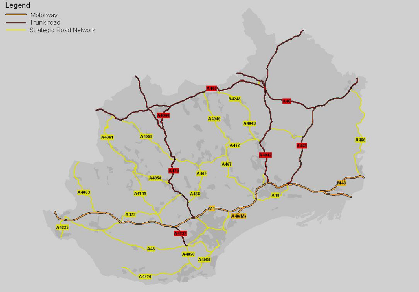
Comprising high quality roads built to appropriate highway design standards, providing the main routes between centres of population and linking with the trunk road network. Routes i) to v) form part of the Regional Transport Plan’s Strategic Highway Network.
The Strategic Highway Network is defined as follows:
-
A467 Pontymister (County Borough boundary) to Llanhilleth (County Borough boundary)
-
A472 Newbridge (A467) to Nelson (County Borough boundary)
-
A472 Crumlin (A467) to Hafodyrynys (County Borough boundary)
-
A469 Ystrad Mynach (A472) to Pwllypant (A468)
-
A468/A469 Penrhos (County Borough boundary) to Pwllypant (A469)
-
A4048 Sirhowy Enterprise Way at Pentwynmawr (A472) to north of Blackwood (A4048/B4251)
Regional Transport Plan Strategic Highway Network
The Strategic Highway Network will be the subject of the following restrictions in respect of new development:
- There will only be a limited number of junctions
- Parking provision will only be permitted where it is located in appropriate designed lay-bys or servicing areas
- New direct access onto the Strategic Highway Network will only be allowed in exceptional circumstances.
County Roads
County Routes link the major population and employment centres in the County Borough to each other and to the Strategic Highway Network.
County Routes are defined as follows:
- A468 Pwllypant (A469) to Lower Machen (County Borough boundary)
- A469 Penrhos (A468) to Caerphilly Mountain (County Borough boundary)
- A469 Ystrad Mynach (A472) to Llechryd (A465)
- A4048 north of Blackwood to north of Hollybush (County Borough boundary)
- A4049 Bryn (A472) to New Tredegar (A469)
In the interests of safety and the efficient movement of traffic, County Roads will be the subject of the following restrictions in respect of new development:
- On-street parking.
- Direct frontage access.
- Turning movements.
Distributor Roads
Distributor Roads provide for the main traffic movements within urban and rural areas, as well as giving access to County Routes and the Strategic Highway Network. This level in the road hierarchy is likely to be important for servicing bus routes.
Distributor Roads are defined as follows:
- B4251 North of Blackwood (A4048) – Gelligroes – Ynysddu – Crosskeys (A467)
- B4252 Pengam (A469) – Maesycwmmer (A472)
- B4254 Trelewis (B4255) – Gelligaer – Pengam (A469)
- B4254 Fleur de Lis (A4049) – south of Blackwood – Penmaen (A4048)
- B4251 Crumlin (A467) – Oakdale Business Park – Chartist Bridge (A4048)
- B4255 Trelewis – Nelson (A472)
- B4257 Pontlottyn (A469) – Rhymney – Llechryd (A465)
- B4256 Rhymney (B4257 – Tredegar (County Borough boundary)
- B4263 Senghenydd – Piccadilly Gyratory (B4623)
- B4511 Argoed (A4048) – Aberbargoed (A4049) plus CIII Bedwellty Road
- B4591 Abercarn (A467) – Crosskeys – Pontymister (County Borough boundary)
- B4600 Penrhos (A468) – Caerphilly Town – Bedwas (A468)
- B4623 Caerphilly Mountain (A469) – Caerphilly Town – Pwllypant (A468)
- CIII Bryn (A4049) – Pontllanfraith – Pentwynmawr (A4048)
- CIII Bedwas Roundabout (A468) – Mornington Meadows – Van Road (Caerphilly Town)
- CIII Caerphilly Town (B4623) – Rudry – Lower Machen (A468)
- CIII Roundabout north of Pwllypant (A469) – Llanbradach – Ystrad Mynach (A472)
- CIII Penpedairheol (B4254) – Cefn Hengoed – Hengoed (A469)
- CIII Pentwynmawr (A4048) – Newbridge – Crumlin (B4251)
- CIII Oakdale Business Park (B4251) – Pentrapeod – Aberbeeg (A4046)
- CIII Gilfach (Park Place) – Western Drive – Northern Bargoed (A469)
- CIII Gilfach (A469) – Northern Bargoed (A469)
- CIII North of Bargoed (A469) – Deri – Pontlottyn (A469)
- CIII St. Cenydd Road (A468/A469) – Lon y Llyn – Watford Road (A469)
- CIII Ystrad Mynach (A472) – Penybryn – Gelligaer (B4254)
- CIII Fleur de Lis (B4252) – Blackwood (B4251)
- CIII Croespenmaen (B4251) – Woodfieldside (A4048) – Pontallanfraith (CIII)
- CIII Heol Cae Barrau (A469) – Nantgarw Road (B4600)
Where appropriate, and especially to facilitate efficient bus operation, County Roads may be the subject of the following restrictions in respect of new development:
- On-street parking
- Direct frontage access
- Turning movements
Access Roads
Access roads are important in terms of local activities, providing access to residential areas, industrial and employment sites, shopping and other services and facilities, town centres and rural communities. They are the estate roads and other roads where pedestrian activity will be commonplace, on which traffic will not automatically have priority, and therefore on which major constraints on traffic movement are likely to be desirable. In practice, management of these local access roads must offer an acceptable compromise between the amenity of local residents and the needs of those passing through the area. That balance will be orientated more towards residential amenity than is possible with roads higher in the hierarchy.
Access Roads are defined as all public roads not identified in either of the above highway classes.
For reasons of safety and amenity, Access Roads may be the subject of the following restrictions in respect of new development:
- Traffic Movement
- Speed
Private Streets
Private streets are the various streets and back lanes that are privately maintained but are available for use by the public. In the fullness of time, subject to the availability of finance to improve them to an adoptable standard and the consent of their owners, all of these will be adopted by the Highway Authority and thereafter will be maintained at public expense. There are also shared private drives, which give access to residential properties. These will always remain private.
Historically the Council has operated a policy restricting the number of dwelling units served by a private drive to no more than 3 units, whilst the now superseded design Bulletin 32 advised that no more than 5 units should be served. Both of these requirements stem from the need to have a basis for setting out where the council will expect new streets to be built to adoptable standard and where they will not. Manual for Streets, the current highway guidance document for new housing layout and design, identifies that there is no statutory basis for such a limit as it reflects that the Council has considerable discretion in exercising its powers of adoption. Manual for Streets also advises that the Council should include a clear local policy on this issue.
The setting of such a limit can have significant implications in terms of the design and layout of larger residential developments. Modern housing layouts seek to utilise shared drives and courtyards as a method of both reducing car born frontages and increasing densities. Private drives tend to increase car born frontages. Private streets and private courtyards serving up to 15 units are also acceptable, providing they are built to an adoptable standard as regards construction depth and evidence is forthcoming as to the arrangements for their future maintenance. Limiting the number of units served by private streets can compromise some designs and there needs to be some flexibility in approach where justification is made on design grounds.
Consequently the Council will adopt a policy of restricting units being served off a private drive to 5 and will allow up to 15 units to be served by a private street or courtyard although for the latter, where the design of a larger housing scheme can provide justification, some degree of flexibility of this limit will be considered.